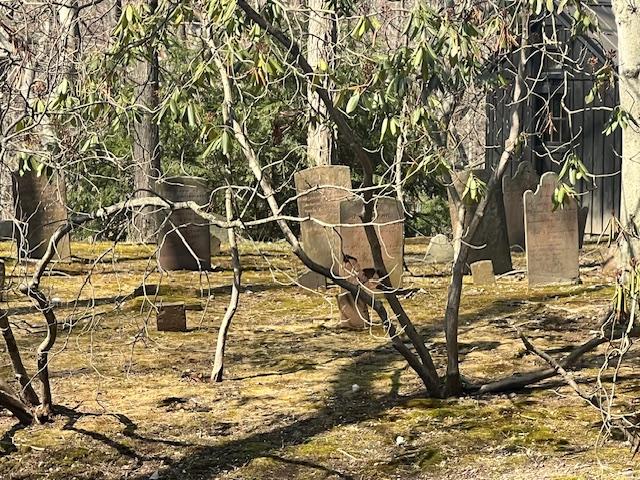
I visited the Alpine Cemetery, which is a historical active cemetery just off Closter Dock Road. This is the resting place of Revolutionary War Veteran, William Wilson and many other veterans from the Civil, Spanish American, World War I and II as well as from Vietnam, Korea and Desert Storm. All the graves were marked with American flags as we just finished Memorial Day weekend.
The family plots that separate the site
My International Marketing class at Bergen Community College recently did a complete study and marketing plan for the “Bergen250” on the Revolutionary War veterans buried at graveyards and cemeteries all over Bergen County, NJ:
For a Mapping of all the historic graveyards and cemeteries, I had the students visit all the sites that the Daughters of the American Revolution had researched and I had the students find all the locations, photo the tombstones and create a bio on each of the veterans. I enclosed a copy of their work above.
My blog on the historic graveyards and cemeteries of Bergen County:
There are many family plots of “First Family’s” of Bergen County like the Westervelt’s, the Haring’s and the Campell’s. The family plots are separated by small fences and some are marked by the family names.
The cemetery on the hill in Alpine, NJ
The separate family burial plots
The Campbell Family burial plot
The Campbell family plots
The Van Sciver family plots
The Anthony Family plots
The Anthony family plot
The Haring Family plot
The Haring family obelisk
The Westervelt family plot
The Jordan/Wilson family plot
I looked at the Wilson family plot for the Revolutionary War veteran but the burial spot is probably has been lost to time. William Wilson may be lost to history but I know he was buried here.
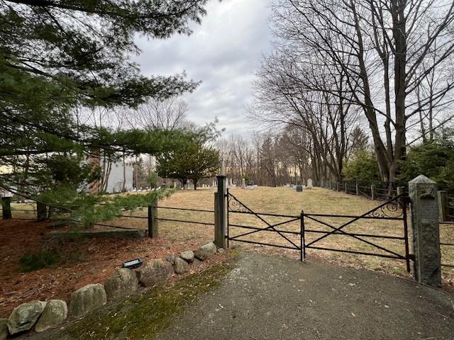
The front part of the cemetery
The Veteran’s Memorial Rock with the names of World War I and II, Vietnam and Korea veterans
The Van Valen family plots
The Pearsall family plots
The Older family plots
The burial grounds from the front
There is a quiet elegance to these historic cemeteries. Who were these people? What did they do? Do people remember them? They are very interesting places to visit.
The history of the cemetery:
(From the historic sign)
The cemetery was founded in 1822 by resident William Gecox along Closter Dock Road when he bought 23 and a half acres as a burial ground for neighbors and for laborers who worked in the area. Mr. Gecox sold these plots on what had already been a burial ground.
The people buried in the cemetery were farmers, laborers, and tradesmen and their family. By 1870, the village “in the Closter Mountain” had take the name “Alpine” in the 1890’s. When William and his wife, Susan Helms pass in the 1890’s, their children sold the remaining plots. The cemetery has continued to be used into the twenty-first century.
The Van Bushkirk Burial Ground behind the residence at 45 East Saddle River Road
The Van Bushkirk Burial Ground is part of the history of Saddle River, NJ’s early settlement period. The burial ground has about 40 tombstones that are arched and shaped. These are some of the first residents both of Saddle River and Bergen County, NJ.
The burial ground lies next to a creek off East Saddle River Road and can only be accessed by going through private property of the residents living at 45 East Saddle River Road. Please do not enter without permission of the owner of the home. These pictures were taken with a long distance camera from the street.
The Van Bushkirk Burial Ground at 45 East Saddle River Road
The History of Saddle River:
(from the Saddle River Town website):
In 1675, Lenni Lenape tribal leaders sold a large amount of land on the Eastern side of the Saddle River (known as Werimus) to Albert Zabriskie. In 1708, Zabriskie sold this tract of land to Thomas Van Buskirk. The first house in Saddle River was built by the Van Buskirk family in 1709. The original Van Buskirk homestead still stands at 164 East Saddle River Road across from Borough Hall.
In 1709, the Lenni Lenape sold the land on the west side of the Saddle River to the English as part of the Ramapo Tract. Property on the west side of the Saddle River was acquired from this Tract throughout the 1700’s. The Ackerman Family was the most prolific buyer of these early Saddle River parcels and first settled on the West side of the Saddle River in 1745 when Johannes Ackerman acquired 245 acres.
My International Marketing class at Bergen Community College recently did a complete study and marketing plan for the “Bergen250” on the Revolutionary War veterans buried at graveyards and cemeteries all over Bergen County, NJ:
For a Mapping of all the historic graveyards and cemeteries, I had the students visit all the sites that the Daughters of the American Revolution had researched and I had the students find all the locations, photo the tombstones and create a bio on each of the veterans. I enclosed a copy of their work above.
My blog on the historic graveyards and cemeteries of Bergen County:
Saddle River continued to grow and populate during the 18th century. Families such as the Van Buskirk’s, the Ackerman’s, the Achenbach’s, the Hopper’s, the Zabriskie’s, the Stilwell’s and the Baldwin’s farmed and developed the area.
The grave of George Achenbach
The first of many Saddle River mills was built in 1714 and the first school was constructed in 1720. Another early 18th century business was the blacksmith shop operated by the Ackerman family. Over the years, these 1st families built the quintessential “Old Dutch Homesteads” from actual sandstone that was found in town.
The Revolutionary War era tombstones
The Revolutionary War was a horrendous time for the residents of Saddle River. The townsfolk had spent the entire 18th century developing the area into a well established community and all growth essentially stopped during the war. Since the Jersey Dutch initially considered the revolution to be an English issue, it was particularly shocking when the fighting came to their backyards. From December 1776 until the end of the war, both American and British forces traveled through Saddle River and many times set up camp in the center of town.
Residents were in constant fear of the British employed Hessian soldiers who would terrorize families by raiding the houses for food and then burning the fields before leaving. Although no major battles took place in Saddle River, there were small skirmishes to fend off raids and the Blue Mill on East Saddle River Road was destroyed. Even George Washington, the future father of our country, passed through Saddle River on multiple occasions and tradition has him staying overnight at the Ackerman Homestead on the East road.
When the Revolutionary War ended, Saddle River residents picked up right where they left off in terms of community and industry development. The Ackerman’s built a Foundry on what is now Waterford Gardens. Tice and Berdan both opened stores in town and the Bulls Head Tavern opened its doors to weary travelers in 1802. Old mills were re-opened and new ones such as Van Riper’s Saw Mill and Basket Factory were established. The post war growth continued for decades and culminated in the 1820s with the construction of the Zion Lutheran Church in 1821 and a new schoolhouse behind the church in 1825.
The worn tombstones in the cemetery
History of the Van Bushkirk family in Bergen County during the Revolutionary War:
(From the Bergen County Historical Society website):
Loyalists in Bergen County came from all backgrounds, religions and economic classes. At the beginning of the war, a number were officers in the militia, the military force composed of all able-bodied males maintained by each province, and later the states. The lieutenant colonel of the militia was John Zabriskie of New Bridge. Zabriskie understood the sentiments of many of his neighbors, particularly those of Abraham Van Buskirk, whose property was directly across the bridge in Teaneck. Van Buskirk was a surgeon in the militia under Zabriskie, and with whom he served on Bergen County’s Committee of Correspondence, an entity established to keep in touch with other New Jersey counties and the events occurring there.
The Van Houton Family Cemetery at 108 Delaware Lane on what was once the family farm
The historic Marker from 1822
The family plot from the entrance of the cemetery
About five generations of Van Houton’s have been buried in this spot, with an impressive list of family members who have served in all the nation’s wars.
From the Revolutionary War up to World War II, the family’s contribution extends not just to Bergen County but our entire country.
My International Marketing class at Bergen Community College recently did a complete study and marketing plan for the “Bergen250” on the Revolutionary War veterans buried at graveyards and cemeteries all over Bergen County, NJ:
For a Mapping of all the historic graveyards and cemeteries, I had the students visit all the sites that the Daughters of the American Revolution had researched and I had the students find all the locations, photo the tombstones and create a bio on each of the veterans. I enclosed a copy of their work above.
My blog on the historic graveyards and cemeteries of Bergen County:
This multi-generational cemetery is still used today by the descendents of John Van Houten, who left the property in his will. The grounds of the cemetery are well maintained. A metal fence around the property could use some minor repairs. Unfortunately a couple of the obelisk markers have fallen off their bases.
In the August 1992 Cemetery Inventory Booklet, published by the Bergen County Department of Parks, Division of Cultural and Historic Affairs, they listed Andrew Schaaf as a contact person for the cemetery, with an address of 749 High Mountain Road, Franklin Lakes, NJ 07417. The same publication mentions that an inventory of the cemetery was done by John Neafie in 1911.
In the 17th century, Lenape Indians traveled the land we now call Franklin Lakes. They made winter camp in the “Clove” near Buttermilk Falls and fished in Micharagrape Pond ( now Franklin Lake).
Slowly, the Dutch settlers made their way west from the Hudson River Valley. In 1701 the East Jersey Proprietors confirmed to Michael Hawden the land around the Pond. In 1772 Franklin Township was formed and included much of northwestern Bergen County. Farming was the major occupation of the early inhabitants, mostly Dutch with the names of Van Winkle, Van Houten, Ackerman, Pulisfelt, Van Blarcom, etc. They built solid farmhouses of sandstone and fieldstone. Fourteen of these historic homes still stand in our Borough.
Some of the original family member tombstones in the cemetery
Mills sprang up along the creeks: sawmills, gristmills, tanneries and forges. Daniel Youman’s Grist Mill on Franklin Lake was probably the first business established (it later served as a saw mill and a cider mill).
The 1876 Walker Atlas showed Franklin Lakes had about 100 residences, 5 mills, 1 tannery, 3 schools, 4 blacksmith and wagon shops, 1 church, 2 hotels, 1 store, and 2 railroad depots.
The railroad stations were built in 1869 when the New Jersey Midland Railroad was extended to Oakland. One station stood at Campgaw on Pulis Avenue, the other at Crystal Lake on High Mountain Road. Residents used the train for commuting, moving goods and mail.
Around the turn of the century, estate houses and mansions began to appear in the area. The industrial revolution brought wealth, and many of the wealthy became “gentleman farmers,” sometimes living here only in the summer. Examples of these houses include the Bartholf-Hughes house on Somerset, the Post-Terhune house on Franklin Lake Road, and the Atterbury-Brockhurst house on Ewing Avenue.
Eventually, the Campgaw section became the civic center of our Borough. In 1922 Franklin Lakes separated from Franklin Township, incorporated, and elected William V. Pulis as its first Mayor.
Edward May built three lakes and started the Shadow Lake Swim Club, which evolved into Shadow Lakes Estates. On the other side of the Borough, J. Nevins McBride purchased land around Franklin Lake and began building single-family homes in Urban Farms.
When Route 208 was extended to Oakland in 1959, Franklin Lakes became more accessible, and by 1980 there were more than 8,500 residents. The completion of Interstate 287 in the early 1990’s stimulated another boom in building. Today, the population of our Borough is 10,422.
From a sleepy rural community to an affluent metropolitan suburb, Franklin Lakes has changed extensively, continuing to be a desirable place to live and raise families.
The Franklin Lakes Historical Society was created to help preserve our Borough’s rich history, while at the same time looking to the future of our unique community and those who choose to make this their home.
The family still uses the cemetery into the twenty-first century
Part of the cemetery into modern times
Multiple family members are often buried together
The cemetery in modern times
The children of Ralph Van Houten who passed within a few years of one another
The grave of Abraham Van Houton and his wife, Bridget
The front part of the cemetery shows the different branches of the family and when they were buried.
The back part of the cemetery is rather old
The Snyder branch of the family
Another branch of the Van Houten family is buried together here
Members of the Ackerman and Cooper side of the family
Conrad and Elizabeth Van Houten
Jacob and Elizabeth Van Houten
Some of the modern graves of the Van Houten’s and Ackerman sides of the family
Many of these small family plots sit on buffs and have the most amazing views. It is as if the final resting place was to be a place of beauty and contemplation.
Unfortunately the family farm is long gone and the cemetery is now surrounded by McMansions. Talk about progress!
The cemetery sits behind the former ‘Ladies Shopping District’ department stores
The front of the cemetery
When I was finishing my walk of the streets of Lower Chelsea, I came across this quiet and respectful cemetery in the middle of a busy neighborhood. This small graveyard was the third of series of moves that Shearith Israel made to bury their dead since the original cemetery open on the edge of what is today Chinatown.
Like its earlier counterparts, the cemetery is locked to visitors. So you can only admire it from a far. The graves date back to the early 1800’s.
The History of the cemetery:
(From the New York City Cemetery Project and Find a Grave)
This cemetery is located on 21st Street between 6th and 7th Avenues, in use 1829-1851. Shearith Israel, the first Jewish congregation in North America, was formed in 1654 by Spanish and Portuguese Jews who journeyed from Recife, Brazil, seeking refuge from the Inquisition.
The entrance to the cemetery is always locked
The sign for the cemetery
While New Amsterdam’s city fathers did not recognize freedom of worship, they respected the Jews’ right to their own consecrated burial ground. Shearith Israel purchased the cemetery plot on West 21st Street in 1829 for $2,750. It, too, was on the outskirts of the expanding city, which for sanitary reasons had prohibited interment below Grand Street after the yellow fever epidemic of 1822.
The view of the cemetery from the fence
In 1832 the congregation bought land extending the cemetery east to Sixth Avenue and south to 20th Street. Fifty years later the land was sold to Hugh O’Neal, who built a dry goods store there. Shearith Israel used the cemetery for burials until 1851.
The graves are from the early 1800’s
That year, New York City prohibited burials south of 86th Street and the establishment of any new cemeteries within city limits (Find a grave.com).
The side section of the cemetery and pathway
The view of the cemetery and its quiet respect to those buried there
The history of the Cemetery from the Congregation of Shearith Israel The Spanish & Portuguese Synagoge website:
According to rules of ritual purity, Cohanim are prohibited from coming into contact with the deceased (except for their immediate family.) This means that ordinarily Cohanim cannot participate in any of the mitzvoth related to burial. One particularly commendable priest, Mr. Lewis I. Cohen, realized that the consecration of a new and unused cemetery afforded him an opportunity to participate in a mitzvah usually off limits to Cohanim. So it was Mr. Cohen who volunteered to dig the first grave for the first burial of the new cemetery in November 1829.
Some of the notable persons laid to rest in the 21st Street cemetery were Moses Levy Maduro Peixoto and Isaac Seixas, ministers of our congregation, and Harmon Hendricks, founder of one of America’s first great industrial companies and whose descendants are still members of our congregation today. Perhaps the most influential person to be buried in the 21st Street cemetery was the great Jewish diplomat and proto-Zionist, Mordecai Manual Noah.
In 1851, the city prohibited burial in Manhattan below 86th Street. Rather than continue to look north (as Trinity Church did), the Congregation searched outside of Manhattan for its next burial ground. Together with Bnai Jeshurun and Shaarei Tefila, the congregation purchased a large plot of land in Ridgewood, Queens.