Tag: mywalkinmahattan.com

Florham Park Historic Preservation Commission/Little Red Schoolhouse & Hancock Cemetery                                                              203 Ridgedale Avenue                                                     Florham Park, NJ 07932

Florham Park Historic Preservation Commission/Little Red Schoolhouse & Hancock Cemetery 203 Ridgedale Avenue Florham Park, NJ 07932

Florham Park Historic Preservation Commission/Little Red Schoolhouse & Hancock Cemetery

203 Ridgedale Avenue

Florham Park, NJ 07932

https://www.facebook.com/pages/category/Community-Organization/Little-Red-Schoolhouse-438800069660078/

https://morriscountyhistory.org/the-little-red-schoolhouse-florham-parks-pride-joy/

Open: Special Events and Pathways tours-Please check their website

Admission: Free but donations are accepted

My review on TripAdvisor:

https://www.tripadvisor.com/ShowUserReviews-g46441-d24156081-r1058925662-Little_Red_Schoolhouse_Museum-Florham_Park_Morris_County_New_Jersey.html?m=19905

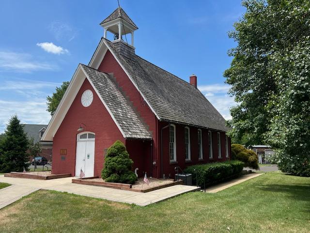
The Little Red Schoolhouse Museum

I visited the “Little Red Schoolhouse” Museum in Florham Park as part of the Morris County’s “Pathways to History” event that is held every May. This interesting little museum showcases the town’s historical collection of items from the 1800’s and 1900’s dealing with all aspects of town life.

The inside of the museum schoolhouse display

The inside of the old classroom

The schoolhouse setting

In the back there is a small classroom set up keeping with the theme of the building. This lets students who are visiting the building of their counterpart’s early education with desks, ink wells and chalk boards that have not changed that much over the years.

Not much has changed in the modern classroom over the years

The old schoolhouse desks

There is early century clothing, farming equipment from the town’s farming past and event Native American objects found in the town and in private collections.

The town artifacts and school items

The post

Other items included decorative items from the home including dishware, home products and furnishings.

Each section of the museum is divided up by lifestyle.

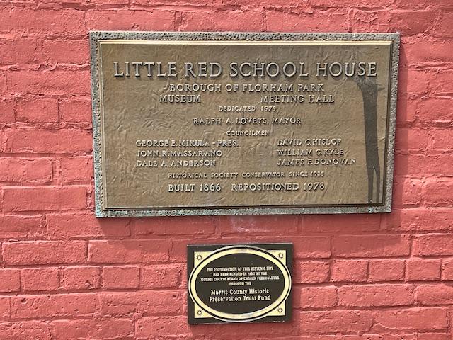
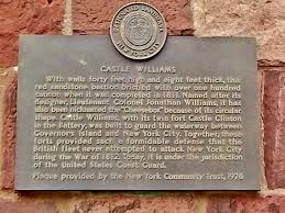
The museum’s historic plaque

The docents that day explained that the items were reflect the town’s past and some came from families that have been in town for years. The museum reflects the community spirit of town’s past. It explains that times have progressed but not changed too much over the years.

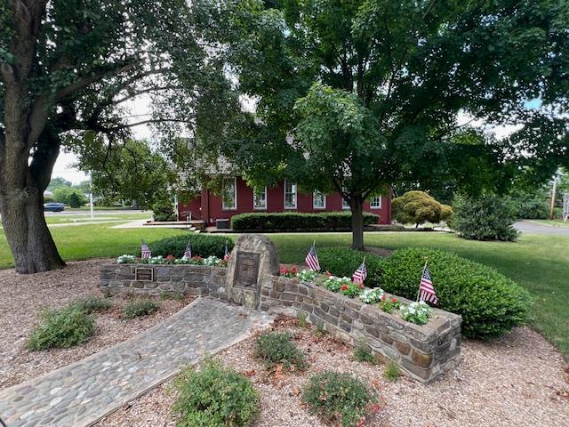
The Veteran’s Monument outside the museum

History of the Little Red Schoolhouse Museum:

(From the Museum Website)

By Kat Kurylko, Research Assistant

In 1830, the residents of Columbia, now Florham Park, sought to improve their thriving farming and broom-making community by establishing a public school for the local children. Therefore, a small schoolhouse, Columbia School #5, was built on the corner of Columbia Turnpike and Ridgedale Avenue and dedicated it on February 17th, 1831.

The schoolroom display

Schooling at the “little red frame building” prospered and so by the 1850’s, the building was “in condition of dilapidation rendering it unfit to be occupied” due to overcrowding.

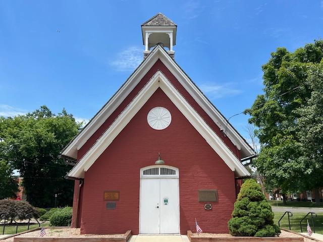
The schoolhouse from the front

On March 1st, 1867, nearly 50 children attended their first class in a new one-room brick schoolhouse. The use of brick added prestige but great expense to the project, accounting for nearly half of the budget. The new building was designed based on principles found in Henry Barnard’s book, “School House Architecture.

Much like Thomas Kirkbride’s progressive hospital designs (illustrated locally at Greystone Park Psychiatric Hospital), Barnard’s method School attendance continued to grow and by 1914, a four-room annex building, which could accommodate 78 students was built on the school’s property and the earlier brick building served as an auditorium.

The inside of the schoolhouse

Eventually, the community outgrew both buildings and in 1934, the borough’s current middle school was constructed.

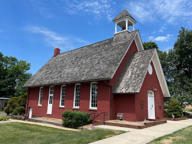
The schoolhouse from the side view

Founded in the 1930’s to preserve the “Little Red Schoolhouse”, the Historical Society of Florham Park now operates the building as a museum. A source of great pride for the local community, the building stands in nearly the same location on the corner of Columbia Turnpike and Ridgedale Avenue, although moved back to accommodate the expansion of Columbia Turnpike. Listed on the NJ and National Registers of Historic Places since the early 1970’s, today the building serves as a reminder of the community’s rural roots.

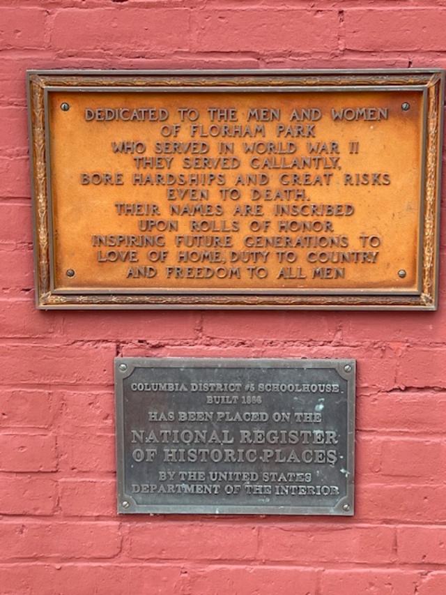
The “Little Red Schoolhouse” Museum historic plaques

(From the Morris County site):

The Little Red Schoolhouse & Museum:

Florham’s Park’s iconic Little Red Schoolhouse was built in 1866 at a cost $2,250. Its open belfry and gable-end entrance instantly identify it as a typical 19th century one-room schoolhouse. The Italianate one-story narrow red brick masonry building is an architectural marvel with its steep roof, tall windows and elaborate arches.

Inside, part of the museum is set up as a 19th century classroom, where small groups can enjoy a lecture. The museum has a variety of artifacts from the 1800’s and 1900’s, vintage school desks and broom-making equipment. Its location at the historic crossroads of Florham Park has remained a key reminder of the borough’s rural origins. The schoolhouse is a stop each fall on the free “Pathways of History” event (which I was on that day I visited).

Town artifacts on display

The school organ on display

Of Special Note:

(from the township website)

*In 1978, the schoolhouse was moved back several yards to accommodate the expanded Columbia Turnpike.

*The schoolhouse is also known as Columbia School District Number 5 Schoolhouse.

*The schoolhouse is the borough’s icon, appearing on the town flag, letter head, website and public works and first responder vehicles.

The Hancock Broom Company artifacts

First Shearith Israel Graveyard/Chatham Square Cemetery                                            55-57 St. James Place                                                             New York, 10038

First Shearith Israel Graveyard/Chatham Square Cemetery 55-57 St. James Place New York, 10038

First Shearith Israel Graveyard/Chatham Square Cemetery

55-57 St. James Place

New York, NY 10038

(212) 873-0300

https://shearithisrael.org/content/chatham-square-cemetery

Open: 24 Hours

Fee: Free

My review on TripAdvisor:

The entrance to the Cemetery

There are times that I walk around Manhattan and things just pop out at you. Tucked inside small pockets of the City are small community gardens, detailed statues, street art and sometimes a small cemetery. I had passed the First Shearith Israel Graveyard or also known as the Chatham Square Cemetery many times when visiting Chinatown since I was a kid. This tiny elevated pocket square of land is located next to a building and locked behind a gate just off St. James Place right at the end of Mott Street strip of Chinatown.

You really have to look for this at the side of 55-57 St. James Place

This is the oldest Jewish Cemetery in Manhattan that was in use from 1683 to 1833. The site of the cemetery was originally on a hill overlooking the East River in an open area at the northern periphery of the British-Dutch colonial settlement. The plot was purchased in 1682 by Joseph Bueno de Mesquita and the cemetery’s first interment was for his relative, Benjamin Bueno de Mesquita. The cemetery expanded in the 1700’s from Chatham Square to the upper part of Oliver Street to Madison Avenue (Wiki).

The original map of the Dutch Colony (New York Historical Society)

In 1823, a City ordinance prohibited burials south of Canal Street and the congregation opened a second burial spot at West 11th Street. A third cemetery was opened at 21st Street west of Sixth Avenue. The size of the cemetery has been reduced over the years because of development and most of the bodies were removed and moved to the other cemeteries. In 1851, the City again prohibited burials below 86th Street and the congregations again opened a fourth cemetery in Ridgewood, Queens. In 1855, with more development changing the area again and over two hundred graves were removed from the site. Only about hundred remain (Wiki).

The inside of the cemetery

Two of the most notable people buried here are Reverend Gershom Mendes Seixas (1745-1816), the first American born Jewish spiritual leader and Dr. Walter Jonas Judah, the second person of the Jewish faith to attend an American Medical School (now Columbia University) and the first native born one. (Wiki). There are also 18 Jewish Revolutionary War era veterans and patriots buried here.

History of the Jewish Settlement in Dutch New York:

In September of 1654, just after the Jewish New Year, twenty-three Jews, mostly of Spanish and Portuguese origin arrived in Manhattan. These people had been living in Recife, the former capital of the 17th Century Dutch Brazil. When the Portuguese defeated the Dutch for control of Recife and brought with them the Inquisition, the Jews of that area left. Some returned to Amsterdam, where they had originated and others moved around the Caribbean to other islands. These twenty-three arrived in New York due a series of unseen events (Big Apple Secrets).

Governor Peter Stuyvesant did not want to permit them to stay but these settlers fought for their rights and won permission to remain. In 1655, the Jewish settlers applied to the Dutch authorities for permission to purchase a parcel of land as an exclusive place to bury their dead. In February of 1656, appealed “that consent may be given” for the purchase. In 1644, the British took New Amsterdam and renamed it New York and the Jews were granted more civil rights. In 1706, they had organized their own congregation, Shearith Israel (Big Apple Secrets).

The cemetery for the most part is pad locked but you can view the outside from the street level. The cemetery is open on Memorial Day for services to the members of the armed services but for the most part you have to view the cemetery from the street level.

Chatham Square Cemetery

The plaque that you can see at eye level just inside the cemetery.

This unique plot of land is easy to miss so look for the plaque at eye level as you pass it.

Castle Williams                                           Governors Island                                                 New York, NY 10004

Castle Williams Governors Island New York, NY 10004

Castle Williams

Governors Island

New York, NY 10004

(212) 825-3054

Open: Check the website. It varies by season

https://www.nps.gov/gois/learn/historyculture/castle-williams.htm

https://www.nps.gov/gois/planyourvisit/explore-castle-williams.htm

My review on TripAdvisor:

https://www.tripadvisor.com/Attraction_Review-g60763-d6952984-Reviews-Castle_Williams-New_York_City_New_York.html?m=19905

My trip to Governors Island on MywalkinManhattan.com in 2018 and 2024:

https://wordpress.com/post/mywalkinmanhattan.com/7658

Castle Williams Fort as you enter from the main walkway

I have toured Castle Williams several times when visiting Governors Island over the last two years. The fort sits at a strategic site on the island facing Manhattan. The fort was originally built to protect New York City from the British during the War of 1812. The British knowing that the City had been fortified for battle never attacked New York.

The historic plaque

The tour takes place twice a day for about an hour and you tour the first two levels of the fort. There are all sorts of signs around to show the history of the fort and its uses over the years. The one thing they don’t like is you touching the walls as the fort is still pretty fragile.

The entrance to this historic fort.

The nicest part of the tour is the observation deck at the top of the fort and the views of the Lower Manhattan skyline. It is a spectacular view of the harbor. You can see by the view why the fort was built where it was built and for its purpose before the War of 1812.

The sign welcoming you to the fort.

It really is a treat to see how fortifications mattered for cities in this time of history in this country.

The History of Castle Williams:

The model of Castle Williams inside the fort.

Castle Williams is a circular defensive work of red sandstone on the west point of Governors Island in New York Harbor. It was designed and erected between 1807 and 1811. It was designed by the Chief Engineer of the U.S. Army Corps of Engineers, Lieutenant Colonial Jonathan Williams for whom the fort was named after. It was considered a prototype for new forms of coastal fortification.

The fort from the outside

The castle was one component of a larger defensive system for the inner harbor that included Fort Jay and the South Battery on Governors Island, Castle Clinton at the tip of Manhattan, Fort Gibson at Ellis Island and Fort Wood, which is now the base of the Statue of Liberty on Liberty Island. This system of forts came to be known as the Second American System of coastal defense and existed to protect harbors like the one in New York from British interference with American Shipping.

The inside courtyard of the fort.

Its usefulness as a fort began to end in the 1830’s, so Castle Williams subsequently served as barracks for the island’s garrison and new and transient troops. The castle was then remodeled by the U.S. Army for use as a prison in various forms during the Civil War and through the first half of the 20th Century.

In 1901, Secretary of War Elihu Root, who worked hard to modernize the Army, made a commitment to preserve the castle and overruled army leaders who wanted to demolish both it and Fort Jay. By 1903, the castle was fitted up as a model, state of art prison facility. In 1947, extensive renovations were carried out with the wooden catwalks replaced by concrete enclosed walk ways, hiding the beautiful stone arches on the third level and resulting in the industrial appearance of the courtyard today. Castle Williams ceased operations as a military prison in 1965 just before the U.S. Army left Governors Island.

The inside of the prison cell.

The Castle again faced a demolition challenge as Coast Guard officials in Washington DC, who took control of Governors Island in 1966, wanted to demolish it. Instead, the castle was remodeled as a youth community center with a nursery, meeting rooms for Scouts and clubs, a woodworking shop, art studios, a photography laboratory and a museum. By the late 1970’s, the community center moved to another location and the fort became the grounds-keeping shop for the Coast Guard base.

Over time, the roof failed and broken windows allowed serious water damage to occur inside the castle. In the mid-1990s, the roof was replaced and new windows stopped further water damage to the structure but the interior remains closed until it can be made safe for public access. The National Park Service proposes to stabilize and restore the castle and eventually provide access to the roof, allowing the public to admire the harbor and the modern skyline of the great city (this has since opened on my last visit).

The view from the top of the hill on Governor’s Island.

Castle Williams was individually listed in the National Register of Historic Placed on July 31, 1972. It was recorded by the Historical American Buildings Survey in 1983. It was designated a National Historic Landmark in 1985 and the New York City Landmarks Historic District in 1996. It has been part of the Governors Island National Monument by Presidential Proclamations signed in 2001 and 2003.

(This information was provided by the National Park System Division of Cultural Affairs).

The lawn of Governor’s Island overlooking Lower Manhattan.

The Highbridge Water Tower                                            Highbridge Park                                                                   Washington Heights, NYC 10022

The Highbridge Water Tower Highbridge Park Washington Heights, NYC 10022

The Highbridge Water Tower in Highbridge Park

Washington Heights around 174 Street

New York, NY  10022

https://www.nycgovparks.org/planning-and-building/capital-project-tracker/project/5937

https://www.nycgovparks.org/park-features/highbridge-park/planyc

The tower from the FDR Drive walkway from below

When I was walking through High Bridge Park while exploring Washington Heights for my blog, ‘MywalkinManhattan.com’, I came across the Water Tower inside the park right next to the pool that was closed for the season and the Highbridge Walkway, which used to be the old aqueduct that used to bring fresh water into New York City.

The Highbridge Water Tower when I walked “The Great Saunter” through the neighborhood in 2023.

The Highbridge Water Tower is nearly 200 feet tall and stands around 174th Street in Washington Heights. The tower used to hold a 47,000-gallon water tank that was fed by the Croton Aqueduct. The Highbridge next to it was the last leg of the aqueduct’s forty-mile journey from upstate New York to Manhattan and is the oldest surviving bridge in New York City (T.M.Rives 2012).

The Highbridge in Highbridge Park

The tower itself was built between 1866-1872 by architect John B. Jervis in the Romanesque Revival and  neo-Greco styles and had a seven acre reservoir next to it. It opened in 1872 and was fully working in 1875. In 1949, the Water tower was disconnected from the system. The tower like the rest of the park had sat in disrepair for years and was restored between 1989-1990 (Wiki). The tower is now going through another restoration that should be finished by April of 2021 (NYCParks.com).

When I visited in the park that summer and then again in the Fall, it was behind fencing because it was still unsafe.

Highbridge Park is beautiful in the Spring and Fall but not the safest park in NYC.

Walking the paths of Highbridge Park

Highbridge Park is a wonderful park to walk around in in the middle of the day during the warmer months. I would not venture around it later at night or in the winter months. It can be a bit desolate and when you walk around the paths by the river with all the abandoned cars and graffiti can be a bit dangerous. I got some looks when walking around.

High Bridge Park V

This was at the bottom of the bridge just off the path.