Tag: mywalkinmahattan.com

First Shearith Israel Graveyard/Chatham Square Cemetery                                            55-57 St. James Place                                                             New York, 10038

First Shearith Israel Graveyard/Chatham Square Cemetery 55-57 St. James Place New York, 10038

First Shearith Israel Graveyard/Chatham Square Cemetery

55-57 St. James Place

New York, NY 10038

(212) 873-0300

https://shearithisrael.org/content/chatham-square-cemetery

Open: 24 Hours

Fee: Free

My review on TripAdvisor:

The entrance to the Cemetery

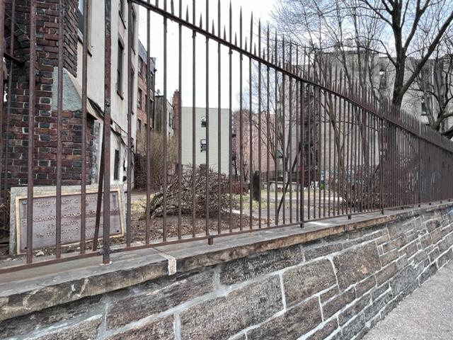
There are times that I walk around Manhattan and things just pop out at you. Tucked inside small pockets of the City are small community gardens, detailed statues, street art and sometimes a small cemetery. I had passed the First Shearith Israel Graveyard or also known as the Chatham Square Cemetery many times when visiting Chinatown since I was a kid. This tiny elevated pocket square of land is located next to a building and locked behind a gate just off St. James Place right at the end of Mott Street strip of Chinatown.

You really have to look for this at the side of 55-57 St. James Place

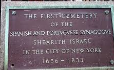
This is the oldest Jewish Cemetery in Manhattan that was in use from 1683 to 1833. The site of the cemetery was originally on a hill overlooking the East River in an open area at the northern periphery of the British-Dutch colonial settlement. The plot was purchased in 1682 by Joseph Bueno de Mesquita and the cemetery’s first interment was for his relative, Benjamin Bueno de Mesquita. The cemetery expanded in the 1700’s from Chatham Square to the upper part of Oliver Street to Madison Avenue (Wiki).

The original map of the Dutch Colony (New York Historical Society)

In 1823, a City ordinance prohibited burials south of Canal Street and the congregation opened a second burial spot at West 11th Street. A third cemetery was opened at 21st Street west of Sixth Avenue. The size of the cemetery has been reduced over the years because of development and most of the bodies were removed and moved to the other cemeteries. In 1851, the City again prohibited burials below 86th Street and the congregations again opened a fourth cemetery in Ridgewood, Queens. In 1855, with more development changing the area again and over two hundred graves were removed from the site. Only about hundred remain (Wiki).

The inside of the cemetery

Two of the most notable people buried here are Reverend Gershom Mendes Seixas (1745-1816), the first American born Jewish spiritual leader and Dr. Walter Jonas Judah, the second person of the Jewish faith to attend an American Medical School (now Columbia University) and the first native born one. (Wiki). There are also 18 Jewish Revolutionary War era veterans and patriots buried here.

History of the Jewish Settlement in Dutch New York:

In September of 1654, just after the Jewish New Year, twenty-three Jews, mostly of Spanish and Portuguese origin arrived in Manhattan. These people had been living in Recife, the former capital of the 17th Century Dutch Brazil. When the Portuguese defeated the Dutch for control of Recife and brought with them the Inquisition, the Jews of that area left. Some returned to Amsterdam, where they had originated and others moved around the Caribbean to other islands. These twenty-three arrived in New York due a series of unseen events (Big Apple Secrets).

Governor Peter Stuyvesant did not want to permit them to stay but these settlers fought for their rights and won permission to remain. In 1655, the Jewish settlers applied to the Dutch authorities for permission to purchase a parcel of land as an exclusive place to bury their dead. In February of 1656, appealed “that consent may be given” for the purchase. In 1644, the British took New Amsterdam and renamed it New York and the Jews were granted more civil rights. In 1706, they had organized their own congregation, Shearith Israel (Big Apple Secrets).

The cemetery for the most part is pad locked but you can view the outside from the street level. The cemetery is open on Memorial Day for services to the members of the armed services but for the most part you have to view the cemetery from the street level.

Chatham Square Cemetery

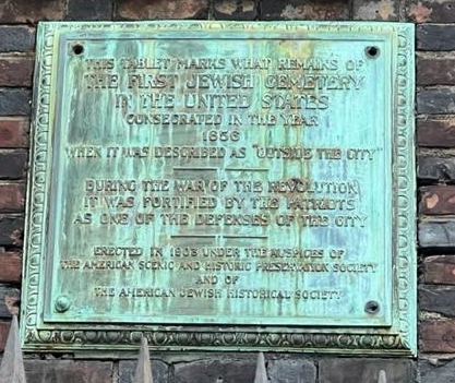
The plaque that you can see at eye level just inside the cemetery.

This unique plot of land is easy to miss so look for the plaque at eye level as you pass it.

Castle Williams                                           Governors Island                                                 New York, NY 10004

Castle Williams Governors Island New York, NY 10004

Castle Williams

Governors Island

New York, NY 10004

(212) 825-3054

Open: Check the website. It varies by season

https://www.nps.gov/gois/learn/historyculture/castle-williams.htm

https://www.nps.gov/gois/planyourvisit/explore-castle-williams.htm

My review on TripAdvisor:

https://www.tripadvisor.com/Attraction_Review-g60763-d6952984-Reviews-Castle_Williams-New_York_City_New_York.html?m=19905

My trip to Governors Island on MywalkinManhattan.com in 2018 and 2024:

https://wordpress.com/post/mywalkinmanhattan.com/7658

Castle Williams Fort as you enter from the main walkway

I have toured Castle Williams several times when visiting Governors Island over the last two years. The fort sits at a strategic site on the island facing Manhattan. The fort was originally built to protect New York City from the British during the War of 1812. The British knowing that the City had been fortified for battle never attacked New York.

The historic plaque

The tour takes place twice a day for about an hour and you tour the first two levels of the fort. There are all sorts of signs around to show the history of the fort and its uses over the years. The one thing they don’t like is you touching the walls as the fort is still pretty fragile.

The entrance to this historic fort.

The nicest part of the tour is the observation deck at the top of the fort and the views of the Lower Manhattan skyline. It is a spectacular view of the harbor. You can see by the view why the fort was built where it was built and for its purpose before the War of 1812.

The sign welcoming you to the fort.

It really is a treat to see how fortifications mattered for cities in this time of history in this country.

The History of Castle Williams:

The model of Castle Williams inside the fort.

Castle Williams is a circular defensive work of red sandstone on the west point of Governors Island in New York Harbor. It was designed and erected between 1807 and 1811. It was designed by the Chief Engineer of the U.S. Army Corps of Engineers, Lieutenant Colonial Jonathan Williams for whom the fort was named after. It was considered a prototype for new forms of coastal fortification.

The fort from the outside

The castle was one component of a larger defensive system for the inner harbor that included Fort Jay and the South Battery on Governors Island, Castle Clinton at the tip of Manhattan, Fort Gibson at Ellis Island and Fort Wood, which is now the base of the Statue of Liberty on Liberty Island. This system of forts came to be known as the Second American System of coastal defense and existed to protect harbors like the one in New York from British interference with American Shipping.

The inside courtyard of the fort.

Its usefulness as a fort began to end in the 1830’s, so Castle Williams subsequently served as barracks for the island’s garrison and new and transient troops. The castle was then remodeled by the U.S. Army for use as a prison in various forms during the Civil War and through the first half of the 20th Century.

In 1901, Secretary of War Elihu Root, who worked hard to modernize the Army, made a commitment to preserve the castle and overruled army leaders who wanted to demolish both it and Fort Jay. By 1903, the castle was fitted up as a model, state of art prison facility. In 1947, extensive renovations were carried out with the wooden catwalks replaced by concrete enclosed walk ways, hiding the beautiful stone arches on the third level and resulting in the industrial appearance of the courtyard today. Castle Williams ceased operations as a military prison in 1965 just before the U.S. Army left Governors Island.

The inside of the prison cell.

The Castle again faced a demolition challenge as Coast Guard officials in Washington DC, who took control of Governors Island in 1966, wanted to demolish it. Instead, the castle was remodeled as a youth community center with a nursery, meeting rooms for Scouts and clubs, a woodworking shop, art studios, a photography laboratory and a museum. By the late 1970’s, the community center moved to another location and the fort became the grounds-keeping shop for the Coast Guard base.

Over time, the roof failed and broken windows allowed serious water damage to occur inside the castle. In the mid-1990s, the roof was replaced and new windows stopped further water damage to the structure but the interior remains closed until it can be made safe for public access. The National Park Service proposes to stabilize and restore the castle and eventually provide access to the roof, allowing the public to admire the harbor and the modern skyline of the great city (this has since opened on my last visit).

The view from the top of the hill on Governor’s Island.

Castle Williams was individually listed in the National Register of Historic Placed on July 31, 1972. It was recorded by the Historical American Buildings Survey in 1983. It was designated a National Historic Landmark in 1985 and the New York City Landmarks Historic District in 1996. It has been part of the Governors Island National Monument by Presidential Proclamations signed in 2001 and 2003.

(This information was provided by the National Park System Division of Cultural Affairs).

The lawn of Governor’s Island overlooking Lower Manhattan.

The Highbridge Water Tower                                            Highbridge Park                                                                   Washington Heights, NYC 10022

The Highbridge Water Tower Highbridge Park Washington Heights, NYC 10022

The Highbridge Water Tower in Highbridge Park

Washington Heights around 174 Street

New York, NY  10022

https://www.nycgovparks.org/planning-and-building/capital-project-tracker/project/5937

https://www.nycgovparks.org/park-features/highbridge-park/planyc

The tower from the FDR Drive walkway from below

When I was walking through High Bridge Park while exploring Washington Heights for my blog, ‘MywalkinManhattan.com’, I came across the Water Tower inside the park right next to the pool that was closed for the season and the Highbridge Walkway, which used to be the old aqueduct that used to bring fresh water into New York City.

The Highbridge Water Tower when I walked “The Great Saunter” through the neighborhood in 2023.

The Highbridge Water Tower is nearly 200 feet tall and stands around 174th Street in Washington Heights. The tower used to hold a 47,000-gallon water tank that was fed by the Croton Aqueduct. The Highbridge next to it was the last leg of the aqueduct’s forty-mile journey from upstate New York to Manhattan and is the oldest surviving bridge in New York City (T.M.Rives 2012).

The Highbridge in Highbridge Park

The tower itself was built between 1866-1872 by architect John B. Jervis in the Romanesque Revival and  neo-Greco styles and had a seven acre reservoir next to it. It opened in 1872 and was fully working in 1875. In 1949, the Water tower was disconnected from the system. The tower like the rest of the park had sat in disrepair for years and was restored between 1989-1990 (Wiki). The tower is now going through another restoration that should be finished by April of 2021 (NYCParks.com).

When I visited in the park that summer and then again in the Fall, it was behind fencing because it was still unsafe.

Highbridge Park is beautiful in the Spring and Fall but not the safest park in NYC.

Walking the paths of Highbridge Park

Highbridge Park is a wonderful park to walk around in in the middle of the day during the warmer months. I would not venture around it later at night or in the winter months. It can be a bit desolate and when you walk around the paths by the river with all the abandoned cars and graffiti can be a bit dangerous. I got some looks when walking around.

High Bridge Park V

This was at the bottom of the bridge just off the path.

Fort Tryon Park                                            Riverside Drive to Broadway                             New York, NY 10040

Fort Tryon Park Riverside Drive to Broadway New York, NY 10040

Fort Tyron Park

Riverside Drive to Broadway

New York, NY  10040

https://www.nycgovparks.org/parks/fort-tryon-park

https://www.nycgovparks.org/parks/fort-tryon-park/history

Open: Sunday-Saturday 6:00am-1:00am

My review on TripAdvisor:

https://www.tripadvisor.com/Attraction_Review-g60763-d2305249-Reviews-Fort_Tryon_Park-New_York_City_New_York.html?m=19905

The Front of Fort Tyron Park

The entrance of the park

I love Fort Tryon Park in Upper Manhattan. It is one of the most beautiful parks in New York City. It is a park of rolling hills, stone paths that hug the hills, interesting garden that are ablaze when in season, shady tree sitting areas and is home to many playgrounds and the Cloisters Museum which is part of the Metropolitan Museum of Art. It has so much to offer a visitor coming into Manhattan from exploring the woods that line the path to looking at interesting art at the museum. This 67 acre park is one of the interesting and complex in New York City.

A city view of the beauty of the park by the Hudson River

The view from The Cloisters by the Hudson River

When you enter the park from Inwood by Broadway, you enter through Ann Loftus Park which is named after a local community leader and is one of the popular parks with kids and families in the area. In the summer months, the fountains and water fixtures are going strong and the kids run around them while the parents lie under shade trees talking to one another.

Ann Loftus Playground

https://www.nycgovparks.org/parks/fort-tryon-park/highlights/11234

When taking the path from Ann Loftus Park and winding up the hills of woods and rock formations is the Hudson River looming in the distance with spectacular views of the Palisades and the large cliffs of Fort Lee, NJ on the other side.

The bathrooms in Ann Loftus Playground

The history of the park

Anne Susan Cahill Loftus biography:

At the top of hill like a crown jewel is the Medieval Galleries of the Metropolitan Museum of Art’s Cloisters Museum. Filled with all the Met’s collections of Religious and Medieval art set into themes of old churches, stained glass windows, flowered courtyards and vistas of the river, it is the perfect place to wonder around.

The Met-Cloisters Museum

Don’t miss the “Hunt of the Unicorn” tapestries.

The Hunt of the Unicorn Tapestry

The Cloisters:

https://www.metmuseum.org/visit/plan-your-visit/met-cloisters

My review on TripAdvisor:

https://www.tripadvisor.com/Attraction_Review-g60763-d106609-Reviews-The_Met_Cloisters-New_York_City_New_York.html?m=19905

As you pass the Cloisters and walk further in to the park, there is still so much more to see and do. The Linden Terrace overlooks the Hudson River with its large shade trees over head and its stone benches to sit and just look in the distance or read a book. This was the site of the original Fort Tryon and is the highest location in the park.

Linden Terrace is a nice place to relax and read a book

The flowers by the Linden Terrace

Further down in the other entrance of the park is Heather Garden, a large path of flowers , bushes and trees with benches lining it. The garden was the Olmstead Brothers when the park was taking shape and is a beautiful place to walk in the Spring and Summer months when the park is in full bloom.

The stairs leading to the Linden Terrace

The plaque for Fort Tryon

The anniversary plaque

The Stan Michels Promenade

The Heather Garden in the front

The Heather Garden was recently remodeled to follow the original design by the Olmstead Brothers.

The Heather Gardens

The Heather Gardens in full bloom

The Gardens facing the George Washington Bridge

The Gardens in full view

There is even a terrace restaurant in the middle of the park, the New Leaf Cafe (See review on TripAdvisor-Closed in 2018) which sits off to the side of the Corbin Circle on the other side of the park. The food is over-rated and very expensive. The last time I ate there the menu was pretty standard. It is a great to take out of towners who want a view of something. It is not worth the trip. The views are nice and in the summer months it is pretty but the food and service are standard.

Fort Tryon Park-New Leaf Cafe

The New Leaf Cafe in Fort Tyron Park (Closed in 2018)

My review on TripAdvisor:

https://www.tripadvisor.com/Restaurant_Review-g60763-d478282-Reviews-New_Leaf_Restaurant_Bar-New_York_City_New_York.html?m=19905

The park has so much to offer in all months of the year especially in the Spring and Summer.

The entrance to Fort Tryon Park

Cabrini Woods Nature Sanctuary in the front of the park

The Cabrini Sanctuary in the Spring 2024

History of Fort Tryon Park:

The area was known by the local Lenape Indians as Chquaesgeck and by the Dutch settlers as Lange Bergh (Long Hill). During the Revolutionary War, the Battle of Fort Washington was fought on this site. The park is built on a high formation of Manhattan schist with igneous intrusions and glacial striations from the last Ice Age (Wiki).

The gardens in the Fort Tryon Park

John D. Rockefeller Jr. bought up most the land in 1917, which by that point had been old estates, to create Fort Tryon Park. He hired the Olmstead Brothers firm, under the direction of Fredrick Law Olmstead Jr., the son of the designer of Central Park,  to design the park and James W. Dawson to create a planting plan. Mr. Rockefeller also bought the collection of Medieval art from sculptor George Gray Barnard and it was the cornerstone of The Cloisters Museum which was built in 1939 (Wiki).

The Fort Tryon gardens in full bloom

The stairs in the park

Through the years the park has seen its ups and downs especially in the 1970’s and 80’s with the decline of finances in New York City. There were extensive renovations when finances got better in the late 90’s and parts of the park were fully renovated. The Fort Tyron Park Trust, a non-profit organization was founded in 1998 to help maintain the park (Wiki).

The Scandinavian Orchestra played in June 2024

Video on the show:

Today it is just an amazing park!

The Jacob Javits Playground is really popular

The Javits Playground was very popular

https://www.nycgovparks.org/parks/fort-tryon-park/highlights/8724

On the recent Great Saunter walk in 2025:

When I walked through the park on the recent Great Saunter walk in 2025, they rerouted us through the park when the Riverwalk was closed for renovation. The park was in full bloom and it was the most spectacular day for a visit.

The entrance of the park on that sunny afternoon

The beautiful colorful tulips at the entrance of the park

The colorful gardens were in full bloom

Everyone was routed through the park on the way to Inwood Park for our rest stop. What I found strange was that the park was so beautiful in full bloom and people were not stopping to relax and just enjoy the views. The gardens were amazing and so colorful.

I stopped to look at the beautiful rock garden

I thought this was so clever. One of the volunteers made this sign up which was so funny!

We walked through the park on our way through the park on the way to Inwood Park.