Tag: Bergen County Historical Site

The Cadmus House: Fair Lawn Museum                               14-01 Politt Drive                                                                     Fair Lawn, NJ 07410

The Cadmus House: Fair Lawn Museum 14-01 Politt Drive Fair Lawn, NJ 07410

The Cadmus House: The Fair Lawn Museum

14-01 Politt Drive

Fair Lawn, NJ  07410

(201) 796-7692

http://www.cadmushouse.org

https://www.facebook.com/profile.php?id=133299403367223

http://www.fairlawn.org/content/203/267/521.aspx

https://www.co.bergen.nj.us/discovering-history/cultural-historic-sites

Open: Check the Fair Lawn Town Website

Fee: Free to the public

My review on TripAdvisor:

https://www.tripadvisor.com/Attraction_Review-g46430-d17707566-Reviews-Cadmus_House-Fair_Lawn_New_Jersey.html?m=19905

I visited the Cadmus House today and it is a very interesting look back on the history of Dutch Bergen County and the town of Fair Lawn, NJ.
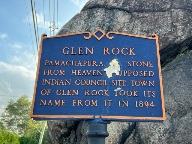
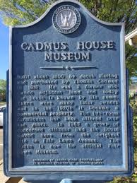
The Marker

The Cadmus House Museum

Jacob Haring: Bergen County resident

https://www.wikitree.com/wiki/Haring-684

http://trees.wmgs.org/getperson.php?personID=I108461&tree=Schirado

The Cadmus House was built in 1808 by landowner Jacob Haring and his wife, Margarat. It was originally a two room farmhouse when it was built on their extensive farm land. The Harings’ sold the house to Abraham and Harmones Van Derbeek in 1815 and they turned around and sold the house to Thomas Cadmus and his  wife, Margaret in 1816 and the name stuck from there.

Cadmus House

The Haring house originally and then it had a gable and second floor built in the late 19th century

More information on the Haring Family from the novel “A Dutch Family for the Middle Colonies” by author Firth Haring:

https://books.google.com/books/about/A_Dutch_Family_in_the_Middle_Colonies_16.html?id=hAZ5AAAAMAAJ

Over the years, the house had had many owners and many uses. Before the house was moved in 1985 to its current location, it served as a real estate office at that time. When they were building new construction on the spot, the house was saved by a group of concerned Fair Lawn residents to preserved the town’s past and it was turned into the Cadmus House-Fair Lawn Museum.

The house is broken down into different themed rooms. The downstairs rooms are devoted to the Fair Lawn’s past with pictures of old homes that used to line the streets of the neighborhood. There are pictures of old farms and farm houses, relics from town such as arrowheads, farming equipment and old farm house decor such as ice boxes and apple presses for cider.

Cadmus House II

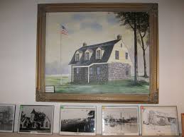
Pictures of Fair Lawn’s past

In the room that once served as a dining room, there are period Dutch items that would be needed to run a household or a business.

Cadmus House Cider Press.jpg

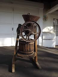
The apple press which was a big part of the farming community in Bergen County

The upstairs rooms have different displays. One room is devoted to Victorian living with furniture and bedroom decors along with dolls and cribs. The other room is dedicated to the history of the Fair Lawn Fire and Police Departments as well as memorabilia from Fair Lawn High School such as trophies, yearbooks and old films of football games.

There is plenty of parking in the front of the house and the parking lot is shared with the railroad station next door. The house is only open the third Sunday of each month and it is closed for the months of July and August.

If you want to take a glimpse of Bergen County’s past Colonial, Victorian, Motor Age or current, the Cadmus House will give you a perspective on living in Bergen County in the past into current times.

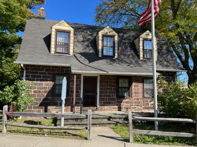
The house now sits by the train station in Fairlawn, NJ

Camp Merritt Memorial Monument Intersection of Knickerbocker Road and Madison Avenue                                Cresskill, NJ 07626

Camp Merritt Memorial Monument Intersection of Knickerbocker Road and Madison Avenue Cresskill, NJ 07626

Camp Merritt Memorial Monument

Intersection of Knickerbocker Road and Madison Avenue

Cresskill, NJ  07626

http://www.bergen.nj.us

http://www.bergencountyhistory.org/Pages/campmerritt.html

My review on TripAdvisor:

Camp Merritt Memorial Monument marks the center of an important World War I embarkation camp, where more than one million U.S. soldiers passed through on their way to and from the battlefields of Europe.

The Front of the Camp Merritt Memorial Site

The inscription on the memorial

In August 1919, the Bergen County Freeholders purchased land for the monument from what was the approximate center of the camp at the intersection of Madison Avenue and Knickerbocker Road in Cresskill. In 1922, work on the shaft commenced. Modeled on the Washington Monument, the memorial is a 65′ high granite obelisk. On the base are the names of the 578 people who died in the camp, mostly as a result of the 1918 worldwide influenza epidemic.

The historic memorial facing the circle lawn

A large Art Deco style carved relief by the sculptor Robert Ingeroll Aitkin (1878-1949) shows a striding “doughboy” with an eagle flying overhead. Set into a large boulder is a copper plaque with a relief of the Palisades, illustrating that Camp Merritt was used as an area for embarkation, designed and made by the local artist Katherine Lamb Tait. In the ground is a three dimensional stone carving of the map of Camp Merritt.

The artist Robert Ingeroll Aitkin

https://en.wikipedia.org/wiki/Robert_Ingersoll_Aitken

https://americanart.si.edu/artist/robert-aitken-40

Artist Robert Ingeroll Aitkin was an American born artist who studied at the California School of Design. He was known for his historical sculptures (Wiki).

The “Doughboy” on the back of the memorial

Camp Merritt Site III

The troops training at the site during WWI

The Camp Merritt Monument was dedicated on May 30, 1924 by a number of state and federal dignitaries. General John J. “Black Jack” Pershing gave the dedicatory address to a crowd of 20,000 people. Camp Merritt, located midway between Cresskill and Dumont and 12 miles from Hoboken, received its first soldiers in October 1917. Originally called Camp Tenafly”, and covering an area that included Cresskill, Demarest, Dumont, Haworth and Tenafly, it was eventually named for General Wesley Merritt, a gallant Civil War officer who was in the service of his country from 1855 to 1900.

The historic marker sits before the memorial

Little publicity surrounded the camp as it was deemed vitally important to keep troop movements a secret. The soldiers would march with their heavy packs and supplies to the trains or over the Palisades to the Hudson River to board boats that would take them to their European-bound ships docked in Hoboken. The last soldier passed through in the beginning of 1920.

The map of the camp behind the memorial

The camp was 770 acres in size and had a capacity of 42,000 men (two thousand of them officers). It was strategically built near major rail lines, facilitating the transport of soldiers to the camp. It contained 1300 buildings of all varieties.  The base hospital alone was composed of 93 buildings. A staff of 300 nurses treated 55,000 sick men. 8000 men representing 40 different nationalities were nationalized in the Camp and made citizens of the US. Camp Merritt had its own newspaper, the Merritt Dispatch established and edited by Charles Philip Barber, which was the only printed record of the camp’s activities. The editor and staff of the Merritt Dispatch were the first to promote the idea of the monument.

Another view of the back of the memorial

After the camp was sold, it suffered three suspicious fires while the buildings were idle, each one worse than the last. The second fire in March of 1921 destroyed a hundred buildings. The third fire was the most spectacular, destroying almost all of what was left of the camp and detonating two stores of dynamite that had been stored for demolition purposes. Eighteen fire companies (including three from New York City, which came by way of the Dyckman Street Ferry) struggled to prevent the fires from spreading to adjacent homes. Other fire companies came from Tenafly, Closter, Bergenfield, Cresskill, Demarest, Teaneck, Hackensack and Palisades.

The Monument is located on the traffic circle and can be reached by foot and is illuminated at night.

The signs from around the circle describing the site:

Sign One:

Sign Two:

Sign Three:

Sign Four:

The closing of the site and purchase from Bergen County, NJ for development.

http://www.bergen.nj.us

2015 Bergen County Division of Cultural and Historic Affairs

Disclaimer: This information was taken directly from a pamphlet from The Bergen County Division of Cultural Affairs & Historic Affairs in Bergen County, New Jersey. You must stop off on one of the side streets to see the monument and the information boards on the site are off to the west side of the circle. Try to walk around the monument on the circle itself to see the most detail.

The ‘Rock’ on Rock Road off Downtown                             Glen Rock, NJ 07452

The ‘Rock’ on Rock Road off Downtown Glen Rock, NJ 07452

The “Rock”

Rock Road

Glen Rock, NJ 07452

https://www.glenrockhistory.org/photography

TripAdvisor Review:

https://www.tripadvisor.com/Attraction_Review-g46466-d2549392-Reviews-The_Rock-Glen_Rock_New_Jersey.html?m=19905

The Rock in Glen Rock, NJ.

The ‘Rock’ where the town of Glen Rock, NJ gets its name from is more than just a rock in the middle of road off the downtown. It has a rich history that is part of the history of Bergen County itself.

Glen Rock was settled around a large boulder in a small valley (glen) from which it gets its name. The boulder, a glacial erratic weighing in at 570 short tons (520t) and located where Doremus Avenue meets Rock Road is believed to have been carried to the site by a glacier that picked up the rock 15,000 years ago near Peekskill, New York and carried it for 20 miles (32km) to its present location.

The Lenape Native Americans called the boulder “Pamachapuka” (meaning ‘stone from heaven’ or ‘stone from the sky’) and used it for signal fires and as a trail marker (Wikipedia).

The Glen Rock Rock

This is an interesting part of Bergen County’s early Native American history and is located right off the downtown area of the town on Rock Road.

Easton Tower                                                        Red Mill Road Route 4 & Saddle River Road                           Paramus, NJ 07652

Easton Tower Red Mill Road Route 4 & Saddle River Road Paramus, NJ 07652

The Easton Tower

Red Mill Road

Route 4 & Saddle River Road

Paramus, NJ  07652

http://www.co.bergen.nj.us

http://bergencountyhistory.org/Pages/redmill.html

Open: Dawn to Dusk

Fee: Free

TripAdvisor Review:

https://www.tripadvisor.com/Attraction_Review-g46712-d12591227-Reviews-Easton_Tower-Paramus_New_Jersey.html?m=19905

The back of the Easton Tower

The historic marker on the back of the tower

I recently visited the Easton Tower on a beautiful sunny day and it really is a treat to see. It is located on the Saddle River Bike Path, so you can access it from the other side of the park and park on that side of the road for easy access. After seeing the tower, take a walk up and down the Saddle River Bike Path. It is really beautiful to follow the river on a nice day. It is really picturesque and a wonderful place to take pictures and enjoy nature.

The historic Red Mill Marker

This information is provided by the Bergen County Division of Cultural and Historic Affairs:

The Easton Tower is a unique historic site in Bergen County, NJ. This stone and wood frame structure was built along the Saddle River in 1900 as part of a private landscaped park in the Arcola area Paramus. Surrounded by busy NJ roadways, it is now adjacent to the County’s Saddle River Bikeway.

The front of the tower on the bike path

The tower sits near the Saddle River in the Saddle River Park

Once used to pump water to irrigate and provide a scenic setting for the estate of Edward Easton, it is a 20 foot rectangular, stone-masonry tower topped with a wood-frame structure and a wood-shingle, gabled roof. On the side is a large wood water wheel, which is under a wood-shingle roof.  The architect Henry Ihnen designed it.

Easton Tower historical information sign

In the 18th century, this area along the Saddle River and near the heavily used Albany Post Road, was the location of many mills. Jacob Zabriskie, a Bergen County Freeholder during the Revolutionary War had leased the 80 acre mill site around 1766 and in 1771 acquired the mill that had been built in the 1740’s. Revolutionary maps identify it as “Demarest’s and Zabriskie’s Mills.”

The Easton Tower in Saddle River Park

Over time it was rebuilt or expanded and in the early 1800’s painted red by its owner Albert Westervelt. It is at this time it  acquired the “Red Mill” name often mistakenly applied to Easton Tower. By the 1800’s, the mill had fallen into disrepair and was demolished circa 1894.

The inside of the tower

The Easton Tower inside

In 1899, Edward D. Easton (1856-1915), bought this almost 48 acre site, which included the mill pond and dam. The area was called “Arcola”. Easton’s father, a teacher, had originally brought his young  family to this area and suggested the name for the new settlement after a town in Italy. Edward Easton was a notable figure in American technological history. He started out as a stenographer, reporter and then a court stenographer In Washington DC, covering many famous trials in the 1880’s. After the 1886 patent was granted for the method of engraving sound by incising wax cylinders, Easton went on to make his fortune in the recording industry. He was a founder and eventually president of the Columbia Phonograph Company, which became one of the three major recording companies at the turn of the twentieth century.

The Easton Tower from the back

After opening an office in New York City, Eaton relocated his family from Washington DC to Arcola. He had a large house built on his property and commissioned the design of a landscaped park. The tower, to be built neat the site of the old Red Mill was a functioning structure pumping water to several fountains. There were also rustic bridges, lakes and expansive lawns. The tower was a favorite of photographers and appears in many contemporary postcards. People came from miles around to this beautiful spot to take boat rides and walks and in the winter, ice skate near the tower. Sources list the Easton home and park as having been used in early silent films.

After Easton’s death in 1915, the property went through various owners. In 1931,  construction of the Route 208 connection with Route 4 at “the Old Mill at Arcola” provided access to the recently opened George Washington Bridge. This destroyed sections of the landscaped park and isolated the tower. In 1940, the 1.26 acres site was sold at a sheriff’s sale to Clyde A. Bogert. The County acquired the tower from the Bogerts and the Blauvelt-Demarest Foundation in 1956. In 1967, the Bergen County Park Commission dedicated the tower. Easton Tower was placed on the State and National Register of Historic Places and in 2008 was completely restored by the County. It can be viewed from the Saddle River Bikeway and visited year round.

Disclaimer: This information is taken from the Bergen County Division of Cultural and Historic Affairs (C) 2015 pamphlet. The Bergen County Division of Cultural & Historic Affairs received an operating support grant from the New Jersey Historical Commission, a division of the Department of State.

Special Note: I visited the site recently and it is hard to get to by car. It is located right off Saddle River Road and it is off on a odd bend in the road. It is a quick turn to the right so pay attention to the directions.