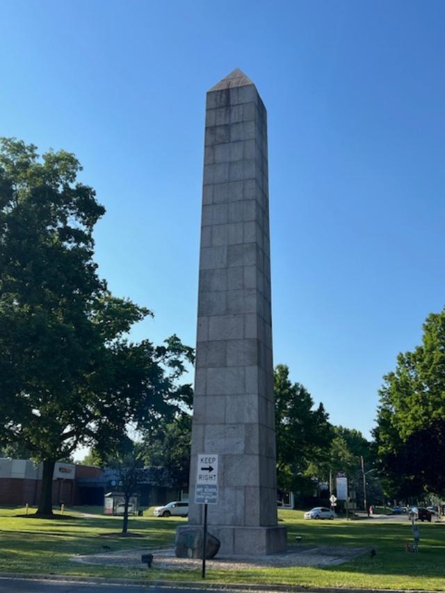
Camp Merritt Memorial Monument marks the center of an important World War I embarkation camp, where more than one million U.S. soldiers passed through on their way to and from the battlefields of Europe.
The Front of the Camp Merritt Memorial Site
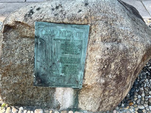
The inscription on the memorial
In August 1919, the Bergen County Freeholders purchased land for the monument from what was the approximate center of the camp at the intersection of Madison Avenue and Knickerbocker Road in Cresskill. In 1922, work on the shaft commenced. Modeled on the Washington Monument, the memorial is a 65′ high granite obelisk. On the base are the names of the 578 people who died in the camp, mostly as a result of the 1918 worldwide influenza epidemic.
The historic memorial facing the circle lawn
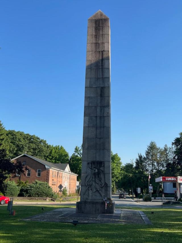
A large Art Deco style carved relief by the sculptor Robert Ingeroll Aitkin (1878-1949) shows a striding “doughboy” with an eagle flying overhead. Set into a large boulder is a copper plaque with a relief of the Palisades, illustrating that Camp Merritt was used as an area for embarkation, designed and made by the local artist Katherine Lamb Tait. In the ground is a three dimensional stone carving of the map of Camp Merritt.
Artist Robert Ingeroll Aitkin was an American born artist who studied at the California School of Design. He was known for his historical sculptures (Wiki).
The “Doughboy” on the back of the memorial
The troops training at the site during WWI
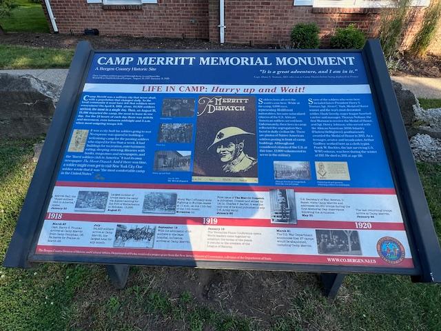
The Camp Merritt Monument was dedicated on May 30, 1924 by a number of state and federal dignitaries. General John J. “Black Jack” Pershing gave the dedicatory address to a crowd of 20,000 people. Camp Merritt, located midway between Cresskill and Dumont and 12 miles from Hoboken, received its first soldiers in October 1917. Originally called Camp Tenafly”, and covering an area that included Cresskill, Demarest, Dumont, Haworth and Tenafly, it was eventually named for General Wesley Merritt, a gallant Civil War officer who was in the service of his country from 1855 to 1900.
The historic marker sits before the memorial
Little publicity surrounded the camp as it was deemed vitally important to keep troop movements a secret. The soldiers would march with their heavy packs and supplies to the trains or over the Palisades to the Hudson River to board boats that would take them to their European-bound ships docked in Hoboken. The last soldier passed through in the beginning of 1920.
The map of the camp behind the memorial
The camp was 770 acres in size and had a capacity of 42,000 men (two thousand of them officers). It was strategically built near major rail lines, facilitating the transport of soldiers to the camp. It contained 1300 buildings of all varieties. The base hospital alone was composed of 93 buildings. A staff of 300 nurses treated 55,000 sick men. 8000 men representing 40 different nationalities were nationalized in the Camp and made citizens of the US. Camp Merritt had its own newspaper, the Merritt Dispatch established and edited by Charles Philip Barber, which was the only printed record of the camp’s activities. The editor and staff of the Merritt Dispatch were the first to promote the idea of the monument.
Another view of the back of the memorial
After the camp was sold, it suffered three suspicious fires while the buildings were idle, each one worse than the last. The second fire in March of 1921 destroyed a hundred buildings. The third fire was the most spectacular, destroying almost all of what was left of the camp and detonating two stores of dynamite that had been stored for demolition purposes. Eighteen fire companies (including three from New York City, which came by way of the Dyckman Street Ferry) struggled to prevent the fires from spreading to adjacent homes. Other fire companies came from Tenafly, Closter, Bergenfield, Cresskill, Demarest, Teaneck, Hackensack and Palisades.
The Monument is located on the traffic circle and can be reached by foot and is illuminated at night.
The signs from around the circle describing the site:
Sign One:
Sign Two:
Sign Three:
Sign Four:
The closing of the site and purchase from Bergen County, NJ for development.
2015 Bergen County Division of Cultural and Historic Affairs
Disclaimer: This information was taken directly from a pamphlet from The Bergen County Division of Cultural Affairs & Historic Affairs in Bergen County, New Jersey. You must stop off on one of the side streets to see the monument and the information boards on the site are off to the west side of the circle. Try to walk around the monument on the circle itself to see the most detail.
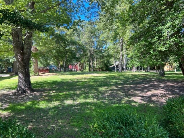
Historic Cold Spring Village in the summer of 2023. The 1800’s came to life when you visit.
The welcoming sign
Historically clothed interpreters demonstrate blacksmithing, pottery, printing, basket weaving and more! Visit an Early American schoolhouse, take part in hands-on activities and crafts and sample historic games and horse-drawn wagon rides on weekdays.
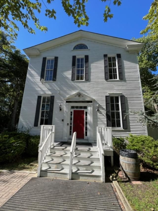
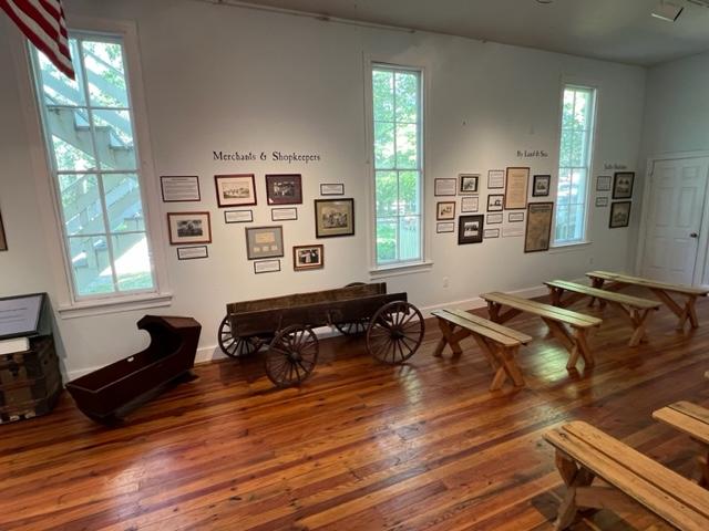
The Visitor’s Center at Historic Cold Spring Village
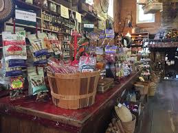
The village is also home to an organic farm complete with a horse, chickens, sheep and more! Visitors will also find a Welcome Center, Country Store, Bakery, Ice Cream Parlor, Cold Spring Grange Restaurant and Cold Spring Brewery.
The Map of the Village
Historic Cold Spring Village is a non-profit, open air living history museum dedicated to preserving the rich heritage of southern New Jersey. During the summer months, interpreters and artisans in period clothing preserve the trades, crafts and heritage of “the age of homespun.” From October-May, the emphasis is on teaching history through school trips to the Village, classroom visits by the education department and interactive teleconferences with schools throughout the U.S.
The Visitor’s Center exhibition is open in off season.
Our Education Program relates the history of the region to the broader scope of New Jersey, American and World History. Historic Cold Spring Village offers programs for students of all ages and programs can be adapted to any grade level. Please contact the Village for a more detailed description of each program.
Historic Cold Spring Village’s educational offerings are designed to comply with the 2009 New Jersey Core Curriculum Content Standards for Social Studies as established by the New Jersey Department of Education.
The Visitor’s Center exhibitions at Historic Cold Spring Village.
Stroll the shaded lanes of Historic Cold Spring Village’s 30 acres as you step back in time to an early American South Jersey farm community. Craft persons, tradesmen, housewives and farmers are eager to share their experience as you visit the Village’s 27 historic buildings. The Village is located on Route 9, four miles south of Rio Grande and three miles north of Cape May City. Visitors from the north, take the Garden State Parkway to Exit 4A and follow the signs to the Village.
For additional information on Historic Cold Spring Village programs, projects or events, please call, fax, email or visit our website.
Give the Past a Future: Invest in the future of HCSV by making a tax-deductible charitable contribution, volunteering or becoming a member. For additional information, call (609) 898-2300, ext. 10.
The Village’s educational programs meet the following standards:
6.1 US History, America in the World
6.2 World History/Global Studies
6.3 Active Citizenship in the 21st Century
The Marshallville One-Room Schoolhouse Experience
In the circa 1850 Marshallville Schoolhouse, students experience a typical Early American school day. Students ‘make their manners’, discover the subject studied by Early American students, write with quill pens and learn the consequences of not following classroom rules.
The Schoolhouse
The Marshallville Schoolhouse is available free of charge for teachers who wish to personally recreate a ‘school day of the past’ for their class. Village staff is available to run the program for a fee.
‘Visits to the Past’
Field trips to Historic Cold Spring Village offer students and teachers the opportunity to experience the past first hand. Select Village buildings, like the print shop, schoolhouse, blacksmith shop and inn are open exclusively for school groups. Costumed interpreters interact with students while demonstrating the trades and crafts of Early America. Field trips are held mid-May through early June. Call or email for fees and dates.
The gift shop offers all sorts of old fashioned goodies
We see America Learning: Teaching Early American History through ‘I Visits’
Distance learning programs are offered to schools nationwide. The programs are delivered via a state of the art broadband IP (Internet Protocol) systems and are adaptable to any grade level. If your school does not have a teleconference camera, our distance learning programs are also available through Skype using just your classroom computer and a webcam.
An Early American School Day: A typical day in an Early American rural school.
The Story of Old Glory: The origins and early history of the flag of the United States, using a collection of reproduction historic flags from the 17th Century through the Civil War.
Past Versus Present: A comparison of contemporary everyday objects with their Early American equivalents for example, a flashlight vs a lantern; digital camera vs daguerreotype.
Four Great Inventions (and one that almost was): Explores the creation of the steam boat, the steam locomotive, the daguerreotype camera, the telephone and difference engine, an 1832 attempt to build a mechanical computer.
Hearth and Home: An exploration of the role of the domestic arts practiced by 1800’s housewife with an emphasis on food preparation including hearth cooking.
Gone for a soldier: A day in the life of a Civil War Infantryman: Includes discussions of uniforms, equipment, camp life, food and weapons.
Welcome Centers: Taverns, Inns and Wayside Stops: A presentation utilizing our circa 1836 Dennisville Inn, A former stagecoach stop in Dennisville, NJ to explain the important part buildings such as these played in a community.
The Inn at the Historic Cold Spring Village
Revisiting the Country Store: An Important Community Resource: A look at the vital role of a general store in the life of rural America as a purveyor of goods, social center, post office, etc.
The War of 1812: More than the Star-Spangled Banner: An overview of the “Second War of Independence”,
Fiber Arts: A domestic program primarily including weaving and spinning interpretations.
The First Frontier: Whaler Yeomen in Colonial New Jersey: The story of the first permanent European settlers in New Jersey as well as a discussion of how the Eastern Seaboard was the original American Frontier.
Early American Trades: Explores the important role a printer, woodwright, blacksmith, bookbinder or tinsmith, had in an Early American community. Includes in-workshop demonstrations.
Disclaimer: This information is taken directly from the Cold Springs Village pamphlet. Please call them at the above number or email address for more information.
This historic site has been restored and administered by the Mid-Atlantic Center for the Arts & Humanities in conjunction with N.J. Department of Environmental Protection Division of Parks & Forestry.
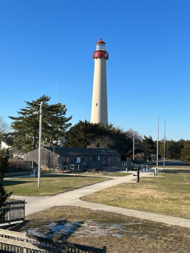
The Cape May Lighthouse: Climb the 199 steps of this 1859 vintage tower for a breathtaking view of the Jersey Cape, where the Delaware Bay meets the Atlantic Ocean.
The History of Lighthouses in New Jersey
Over the past 30 years, MAC has totally restored the Cape May Lighthouse. A fully accessible Visitors Center is located in the adjacent Oil House as well as a Museum Shop stocked with lighthouse and maritime must haves.
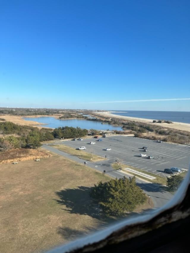
The view of the beach from the lighthouse
The Cape May Lighthouse
Lighthouse information story boards
Lighthouse FAQ
Frequently asked questions about the Cape May Lighthouse
Questions about the structure:
*How Tall is the lighthouse? The lighthouse is 157 feet 6 inches tall from the ground line to the ventilator.
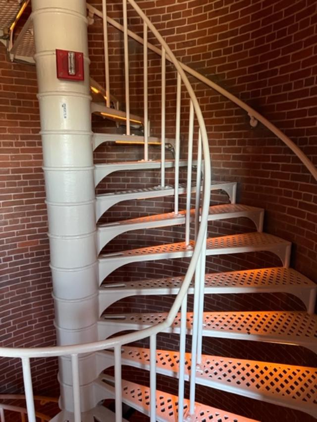
*How many steps are there to the top? There are 217 steps from the ground to the top with 199 steps in the tower’s cast iron spiral staircase.
The staircase going to the lighthouse lens
Looking down the stairs on the way back down
* How old is the Lighthouse? The Cape May Lighthouse was built in 1859 and is the third fully documented lighthouse to be built at Cape May Point. The first was built in 1823; the second in 1847. The exact locations of the first two lighthouses are now underwater due to erosion.
*How thick are the brick walls? The Lighthouse actually has two separate walls. The outside wall is cone-shaped and is 3 feet 10 inches thick at the bottom and 1 foot 6 inches thick at the top. The inside wall is a cylinder with 8.5 inch thick walls which support the spiral staircase. The walls were designed to withstand winds several times above hurricane force.
The view on the way up the lighthouse
*Is the beacon still working? Yes, The Coast Guard continues to operate the light as an active aid to navigation. The light is visible 22 miles out to sea and flashes every 15 seconds. A lighthouse’s flash pattern is called its ‘characteristic’, every lighthouse has its own light characteristic and exterior paint scheme (called a daymark) so that ship captains can tell them apart.
The lighthouse lens
The lighthouse lens
*What were the two small rooms on either side of the entrance hallway used for? They were storage rooms that held tools, implements and fuel for the lantern before the Oil House was built. The keeper also used one as a small office.
The lighthouse office
*Who owns the Lighthouse? The State of New Jersey owns the Lighthouse but the Coast Guard maintains the beacon apparatus. The Mid-Atlantic Center for the Arts & Humanities (MAC) in Cape May leases the Lighthouse from the State with the mission of restoring the structure and operating it as a historic site.
View from the top of the lighthouse
View from the top of the lighthouse
Cape May Lighthouse
*Questions about Lighthouse Keepers and their responsibilities
*Who worked at the Lighthouse? The Lighthouse was staffed by keepers who worked for the U.S. Lighthouse Service. Cape May’s lighthouse generally had one head keeper and two assistants. They carried the oil to the top of the tower every day to power the light and kept the lens apparatus clean and in working order. Keepers’ pay averaged $600.00 a year around the turn of the 20th century.
*Where did the keepers live? There were two houses built right next to the Lighthouse around 1860 for the keepers and their families. One has since burned but the other is still standing on the other side of the fence near the entrance to the tower.
Important Dates: Cape May Lighthouse
1853-First recorded lighthouse constructed. The 1823 tower was 68 feet tall and its location is now underwater due to erosion.
1847-The second lighthouse was built. It was a 78 foot tower located directly in front of the present tower, just beyond the present shoreline. It was replaced by the present lighthouse because it was poorly constructed.
1857-The Army Corps of Engineers began construction on the present tower, which cost $40,000 to build. The first order Fresnel lens, which is now in the Cape May County Museum, cost about $15,000.
1859-The Lighthouse was first lighted on October 31. The next year, two lighthouse keepers dwellings were built. The one remaining is now used by the State Park Service.
1893-The oil house was constructed.
The Oil House
1902-One of the keepers’ dwellings was enlarge to provide more space for housing the keepers’ families. Three keepers and their families. Three keepers and their families lived at the lighthouse site.
1902-An incandescent oil vapor lamp was installed and replaced the Funck multiple wick first order hydraulic float lamp that dated back to 1878.
1933-The light apparatus was electrified.
1936-The light apparatus was automated which eliminated the need for lighthouse keepers being permanently stationed at the tower.
1939-The United States Lighthouse Service was discontinued and its equipment and personnel transferred to the U.S. Coast Guard.
1941-The Lighthouse was darkened until 1945 because of the World War II. The Atlantic coast was on black-out due to the presence of enemy submarines.
1946-A DCB-36 rotating light (like an airport beacon) was installed. The original first order Fresnel lens was placed in the Cape May County Museum.
1986-The Lighthouse was leased to MAC by the State of New Jersey Department of Environmental Protection, Division of Parks and Forestry, who in turn leased the structure from the Coast Guard.
1988-MAC undertook public safety improvements that allowed the public to climb to the top.
1989-A grant from the Bicentennial Lighthouse Fund underwrote the restoration of the Lighthouse’s windows and doors.
1990-The oil house was restored and adapted for use as orientation center and museum shop, with funding from the Bicentennial Lighthouse Fund and the New Jersey Historic Trust.
1992-The ownership of the Lighthouse was transferred from the Coast Guard to the State of New Jersey.
1994-Grants from the New Jersey Historic Trust and the federal ISTEA program administered by the State DOT funded painting of the tower and restoration of the lantern and roof.
1998-Grants from the same agencies funded all remaining restoration of the lighthouse structure.
2000-2001-A grant from the New Jersey Historic Trust funded the grounds restoration project.
2002-The Coast Guard installed a modern light known as a DCB-224. It uses parabolic mirrors to focus the beams rather than lenses.
2010-The Friends of the Cape May Lighthouse group was formed. You are cordially invited to join. Call 609-884-5404 or visit http://www.capemaymac.org.
2016-The Coast Guard installed a new, state of the art beacon known as VRB-25 (Variable Rotating Beacon) replacing the DCB-224 that had suffered irreparable damage due to a lighthouse strike.
2017-Lighthouse Tower was repainted with grants from the Cape May County Open Space Board, the National Maritime Heritage Grant program of the National Park Service and South Jersey Industries, augmented by the fundraising efforts of the Lighthouse Keepers and the Friends of the Lighthouse.
*Is the Lighthouse haunted? Exit Zero Ghost Writer and psychic medium Craig McManus has visited the Lighthouse and detected the ghosts of several former keepers and their families. Perhaps you may encounter them yourself on a Ghosts of the Lighthouse Trolley Tour!
Questions about Lighthouse Restoration
*Why is the Lighthouse leased to the Mid-Atlantic Center for the Arts & Humanities (MAC)?
In the 1980’s , the Coast Guard began a nationwide program of leasing lighthouses to private organizations, like MAC, which are capable of preserving them. In 1986, the Coast Guard leased the Lighthouse to MAC, which assumed the responsibility for its restoration, maintenance and operation as a lighthouse museum. In 1992, ownership of the Lighthouse was transferred from the Coast Guard to the State of New Jersey in order to make the restoration project eligible for state historic preservation funding. The state monitors the historical authenticity of the restoration and also makes available to Lighthouse visitors the parking and restroom facilities of the adjacent state park.
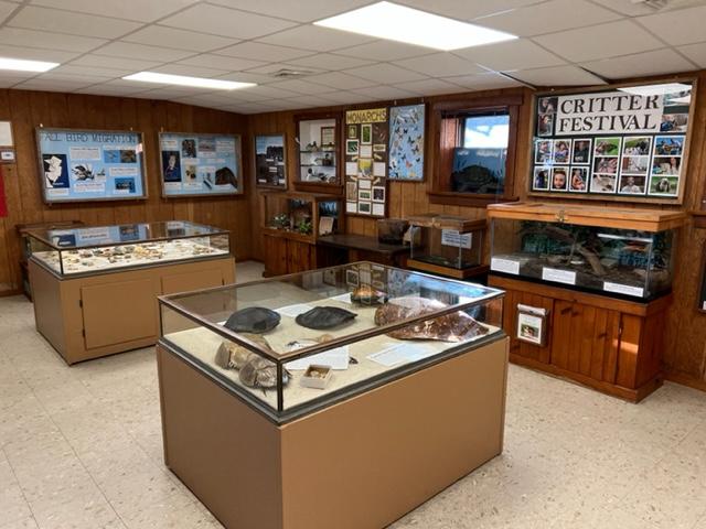
The Museum at the bottom of the lighthouse
*What is MAC?
MAC is a non-profit organization with nearly 4,000 members that was founded in 1970 to save and restore Cape May’s Physick Estate and operate it as a historic house museum. The Physick Estate is also home to the Carroll Gallery with an array of changing exhibitions, a museum shop and the Carriage House Café & Tearoom. MAC has also restored the World War II Lookout Tower (Fire Control Tower Number 23) located nearby on Sunset Boulevard. In addition, MAC promotes Cape May’s Victorian heritage through a year round schedule of special events and trolley, walking and historic house tours. MAC is also one of the area’s leading sponsors of the performing arts with its Cape May Music Festival every May and June. Please call 609-884-5404 for details on MAC’s calendar of events or visit our website at http://www.capemaymac.org.
*How much did it cost to restore the Lighthouse?
Since 1987, closed to two million dollars has been spent to restore the Lighthouse and oil house and allow the public to climb safely to the top.
*Is the Lighthouse open to the public?
Yes, Hours of operation vary throughout the year. The tower is open daily, April through November and on weekends most of the rest of the year. The grounds ground floor, tower and watch room gallery are open to the public. All tours of the tower are self-guided.
Disclaimer: This information was taken directly from a pamphlet from the MAC Cape May Lighthouse Museum. Please call the above number or email address for more information on the site. It is well worth seeing just for the view alone.
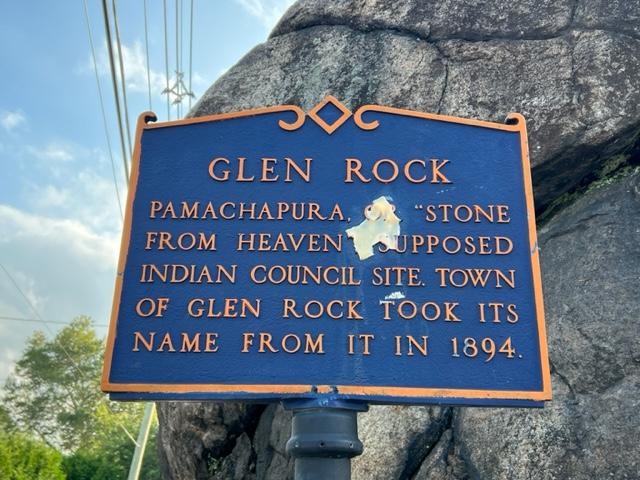
The ‘Rock’ where the town of Glen Rock, NJ gets its name from is more than just a rock in the middle of road off the downtown. It has a rich history that is part of the history of Bergen County itself.
Glen Rock was settled around a large boulder in a small valley (glen) from which it gets its name. The boulder, a glacial erratic weighing in at 570 short tons (520t) and located where Doremus Avenue meets Rock Road is believed to have been carried to the site by a glacier that picked up the rock 15,000 years ago near Peekskill, New York and carried it for 20 miles (32km) to its present location.
The Lenape Native Americans called the boulder “Pamachapuka” (meaning ‘stone from heaven’ or ‘stone from the sky’) and used it for signal fires and as a trail marker (Wikipedia).
The Glen Rock Rock
This is an interesting part of Bergen County’s early Native American history and is located right off the downtown area of the town on Rock Road.