Tag: bergencountycaregiver

Assateague Island National Seashore                 7307 Stephen Decatur Highway                    Berlin, MD 21811

Assateague Island National Seashore 7307 Stephen Decatur Highway Berlin, MD 21811

Assateague Island National Seashore

7307 Stephen Decatur Highway

Berlin, MD 21811

(410) 641-2120

http://www.dnr.state.md.us/public-lands/eastern/assateague.asp

https://www.nps.gov/asis/index.htm

TripAdvisor Review:

https://www.tripadvisor.com/Attraction_Review-g57603-d106596-Reviews-Assateague_Island_National_Seashore-Assateague_Island_Maryland.html?m=19905

Bloggers Note: Over the holidays we visited this national park in Delaware when we were visiting my mother. We went to see the wild horses. The horses were so used to seeing humans that they just ignored us. On a beautiful day, it is nice to visit the island and just look at the ocean.

Barrier Islands are among the most dynamic land forms on earth. From ocean to bay, Assateague Island is defined by change.

The rhythms of tides and seasons shape the island. The smallest gust of wind or gentlest of waves moves sand in a ceaseless rearrangements of island terrain. While summer waves and long-shore currents may build a wide beach, most of the year sand is scoured from the shore and moved southward leaving a narrow, steep shoreline. Storms can create inlets or fill them in. They can cut away dunes and wash sand across the island. The retreating dunes mark the islands’s westward movement. New habitats are created-old ones are reinvented. Plants and animals shift and adapt in counterpoint to these changes. On Assateague Island, nature’s rhythmic processes are a brilliant display.

Assateague Island III

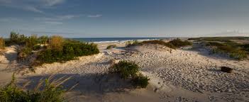
Natural zones shaped and reshaped by wind, wave and current characterize Assateague Island. Distinct plant and animal communities have adapted to each zone. This north-facing view depicts these habitats, left to right from bay to ocean.

Coastal Bays:

Chincoteague Bay and two smaller bays separate Assateague from the mainland. They provide an environment rich in aquatic life and vital to ocean ecosystems. The warm, shallow waters create a productive nursery for mussels, crabs, clams, terrapin and fish. Twice a day, tides rejuvenate these areas and ferry aquatic animals out to the ocean or into the relative safety of the bays.

Just beneath the bays’ surface, in the shadowy world of the seagrass meadows, diverse marine life thrives. Blue carbs molt, hidden in the grasses. Young fish find refuge from predators. Seahorses and pipefish, vulnerable in open water, depend on grasses for anchorage and safe haven. Mud-loving creature cluster around roots. These are the secret gardens of the coastal bays.

Assateague Island II

Salt Marsh:

Once considered worthless, salt marshes are incredibly valuable areas. They are complex ecosystems defined by the constant ebb and flow of salt water. Tides transport nutrients into the marsh and detritus (decaying plants and animals) out into the bay. Scavengers, like snails, amphipods and fiddler crabs, feed on detritus. They in turn are food for high tide visitors to the salt marsh like fish and crabs. When the tide is out, a banquet is exposed in the mudflats where birds feast on the small creatures that inhabit this transitional area. Few plants can thrive in a salt marsh. Cordgrass, salt meadow hay and saltwort are among those that can. These plants create shelter for willet and rail and hunting grounds for Northern harrier and raccoon. Horses can often be seen grazing on marsh grasses.

Maritime Forest:

The forest edge is bordered by a shrub thicket on both bay and ocean sides. This is another transition area between distinct communities. Greenbrier, highbrush blueberry and bayberry thrive here. Trees, stunted and sculptured by salt-laden winds, mingle with shrubs and vines. Guarded by this thicket, the maritime forest is sheltered from much of the wind and provides habitat for some of Assteague’s other residents. While lobolly pine is the dominant tree, southern wax myrtle, American holly and red cedar survive in the shaded understory. The forest is home to white-tailed and sika deer, raccoons and birds like the yellow-rumped warbler and Eastern towhee. Predators like great horned owls and red fox hunt small mammals, birds and reptiles in the woodland.

Dunes and Upper Beach:

The dunes and upper beach are always in motion. Windblown sand and salt dictate the plant and animal life of this stark environment. Less salt-tolerate plants like beach heather and seaside goldenrod hide on the leeward side of dunes, sheltering the small but fierce dune wolf spider as it hunts its insect prey. Plants trap sand, elevate dunes and form a malleable barrier against the assault of wind and water. Where overwash does occur, piping plovers and other birds find prized nestling habitat. The primary beach front dunes are dominated by American beach grass, with its extensive root system and ability to tolerate relentless exposure to the elements. Many creatures visit the beach but ghost crabs enjoy a great view from oceanfront burrows.

Asseategue Island

The wild horses on the island are a main attraction

Ocean:

So visually compelling are the surf and ocean that it is easy to forget how much happens beneath the surface. Mole crabs, coquina clams and small invertebrates thrive in the inter-tidal zone where crashing waves deliver food and render all homes temporary.  Shore-birds dance away from the surf while attempting to dine on creatures concealed in the sand.

The ocean food web starts with phytoplankton. Most other marine life is dependent upon these tiny plant for survival. The oceans support more than half the species on earth, yet 95% of these waters remains unexplored, offering endless possibilities for discovery.

Surf and Seashore Safety:

National Park Service lifeguards cover North Ocean Beach (Maryland) and Tome Cover Beach (Virginia, in the National Wildlife Refuge) in Summer only Assateague State Park also had lifeguards in the summer.

Mats and floats except U.S. Coast Guard-approved personal flotation devices are prohibited at all life-guarded beaches. Surf conditions are posted in multiple locations near the beach. Learn about rip currents (seaward currents) and their danger at http://www.ripcurrents.noaa.gov. Never swim alone.

Prevent overexposure to sunlight with sunscreen or protective clothing. Biting insects are abundant spring through autumn. Insect repellent and/or protective clothing are recommended.

About your visit:

Assateague Island National Seashore is open year-round. Camping is allowed in designated areas only. Campers may not bring firewood from out of state. Firewood must be purchased locally. Assateague Island Visitor Center is open from 9:00am-5:00pm year round except Thanksgiving Day and December 25th. Here you can get information and see aquariums, a touch tank, exhibits, maps and a film about the island’s wild horses. You can register for camping and get permits for the Over Sand Vehicle (OSV) zone at the campground office on the island. Dates and hours vary for Toms Cove Visitor Center. Contact the park for information; phone and website at right.

Chincoteague National Wildlife Refuge, managed by the U.S. Fish and Wildlife Service is open year-round. The Herbert H. Bateman Educational and Administrative Center is open year-round except December 25th and January 1st. Hours vary seasonally. Contact the refuge for information; phone and website at right.

Assateague State Park’s beach and parking lot are open year-round, 9:00am to sunset. Contact the park for camping information; phone and website at right.

Accessibility: Visitor centers, restrooms, bookstores and some trails are wheelchair-accessible. Service animals are welcome. Call each area for more specifics.

Regulations: Call or visit each area’s website for regulations on firearms, pets, personal watercraft and more.

Assateague Island National Seashore is one of over 390 parks in the National Park System. To learn more about national parks, visit http://www.nps.gov.

The Parks:

Assateague State Park: Maryland’s only oceanfront state park has two miles of beach for swimming, surfing and fishing. Lifeguarded areas are available Memorial Day through Labor Day. The campground is open late April through October Campsites include fire rings, picnic tables and bathhouses with warm showers. A small number of electric hookups are available. Reservations are recommended. Alcohol is prohibited in all areas of the state park. A park store is open seasonally, offering food and souvenirs. Pets are permitted with restrictions in designated areas. The marina/boat launch; located on the mainland side of the Verrazano Bridge, is a popular fishing and crabbing spot and features seasonal kayak rentals. Visit the Nature Center in the campground for live animal exhibits, arts and crafts and family fun. Entrance fees apply. Assateague State Park offers something for everyone.

Assateague State Park

7307 Stephen Decatur Highway

Berlin, MD  21811

(410) 641-2120

http://www.dnr.state.md.us/public-lands/eastern/assateague.asp

Assateague Island National Seashore:

Explore the national seashore and discover the mysteries of a barrier island. Before traveling across the Verrazano Bridge to the Maryland end of the island begin your visit at the Assateague Island Visitor Center. Watch a film about the wild horses. The visitor center also includes restrooms, a gift shop, exhibits, aquariums and staff to provide information and orientation. Touch a sea snail or horseshoe crab. Ask at the information desk for a Junior Ranger booklet and have some family fun.

Enjoy the park roads by bike. Observe wild horses feeding in the salt marsh. During summer, visit the Beach Hut for supplies and beverages and swim at the lifeguarded North Ocean Beach. Camping is available a year-round and reservations are encouraged April 15th through October 15th. Expect rustic conditions, vault toilets and coldwater showers. Electric hookups are not provided. Pets are permitted in designated  areas. Avid paddlers and hikers should not miss the countryman camping experience. The Over Sand Vehicle (OSV) zone provides an adventurous getaway (permit required). Nature trails, beach-combing and ranger-led programs will bring back childhood memories, while guided kayak tours and campfire programs will make new ones. Entrance fees apply.

Assateague National Seashore

7206 National Seashore Lane

Berline, MD  21811

(410) 641-1441

http://www.nps.gov.asis

Chincoteague National Wildlife Refuge:

Originally established to protect migratory birds, the refuge today is a destination for birders, beachcombers, anglers and outdoor enthusiasts. Careful management of freshwater pools and marshes provides ideal habitat and feeding areas for migratory waterfowl, shorebirds and other wetland-dependent species. The refuge is a paradise for birders and photographers. Walk or bike the trails to catch a glimpse of the rare Delmarva Peninsula fox squirrel or the Chincoteague ‘ponies’. Drive the Wildlife loop around Snow Goose Pool between 3:00pm and dusk. Expect Toms Cover Hook to be closed during the nesting season of the threatened piping plover. Visit the Refuge-operated Herbert H. Bateman Educational and Administrative Center and the National Seashore-operated Toms Cove Visitor Center for exhibits, programs and assistance. There is no camping in the refuge, so check in the nearby community of Chincoteague. A lifeguarded beach is available Memorial Day to Labor Day. Pets are prohibited Entrance fees apply.

Chincoteague National Wildlife Refuge

8231 Beach Road

Chincoteague, VA  23336

(757) 336-6122

chinco.fws.gov

Disclaimer: This information is taken directly from the National Park Service pamphlet on Assateague Island National Seashore State Park. It is really a fascinating place. It covers both Delaware and Maryland. Please check out the website and call for more information.  Don’t miss this interesting ‘gem’.


The Blauvelt Art Museum                                   705 Kinderkamack Road                               Oradell, NJ 07649

The Blauvelt Art Museum 705 Kinderkamack Road Oradell, NJ 07649

The Blauvelt Art Museum

705 Kinderkamack Road

Oradell, NJ  07649

Phone: (201) 261-0012

(w) blauveltartmuseum.com

(e) info@blauveltartmuseum.com

https://www.blauveltartmuseum.com/current.html

This interesting little ‘gem’ is located up on the hill next to Blauvelt Mansion and is easy to miss. You will see the signs as you drive past it.

Open: Wednesday, Thursday and Friday: 10:00am-4:00pm/Saturday and Sunday: 2:00pm-5:00pm

Fee: Free donations accepted

The Blauvelt Art Museum is funded by the Blauvelt-Demarest Foundation and is a member of the New Jersey Association of Museums, the Mid-Atlantic Association of Museums and the American Association of Museums.

TripAdvisor Review:

https://www.tripadvisor.com/Attraction_Review-g46706-d10628647-Reviews-Hiram_Blauvelt_Art_Museum-Oradell_New_Jersey.html?m=19905

The Blauvelt Art Museum was established in 1957 by the Blauvelt-Demarest Foundation, a legacy of the late Hiram Blauvelt, philanthropist, conservationist and collector. Through the contribution of his private wildlife art and big game collections, he hoped to promote the cultural value of wildlife art and the need for conservation of its subject and their habitats.

The fountain outside the museum

The entrance to the museum.

During the early part of the 20th Century, wildlife was believe to be abundant. Many dedicated conservationists, notable Theodore Roosevelt, gathered animals from their natural habitats for museums. The beauty of the animals could then be viewed by many.

The entrance to the museum.

Like Roosevelt, Hiram Blauvelt realized the value of his collection and wanted to share it with the public. It was his interest and desire to share his far ranging adventures, his stories of explorations and his collection of these animals. Hiram hoped to educate the coming generations to the diversity and beauty of the wildlife kingdom. He especially wanted to enlighten the public to the challenges we face to preserve the marvels of wildlife and their natural environments.

The interesting artwork by the carriage house of pelicans.

The Pelican art outside the museum.

Founded in 1957 as a natural history museum, it introduced students, scouts and youth groups to the need to support wildlife and habitats conservation. Visiting artists created drawings and paintings from close observations of the specimens.

Embracing Penguins outside the museum dedicated to Wildlife Art.

Twenty-five years later, the Board of Directors of the Blauvelt-Demarest Foundation decided that the original objectives would be best achieved by redesigning the museum to feature the works of contemporary wildlife artists, built on the artistic foundation of the Blauvelt’s early collection of works by Charles Livingston Bull (notably a resident of Oradell at one time), Carl Rungius and a complete Audubon Folio of birds of America.

The interesting wildlife artwork just outside the museum.

The Blauvelt Museum, located in an 1893 cedar shingle and turret carriage house, underwent extensive renovations to accommodate its new and expanded mission. The original carriage house was re-designed to include a large reception area, 4 mini galleries and museum offices, all with original materials from the historic building and preserving its aura.

The Blauvelt Art Museum lion statue “Fides et Virtus” by artist Aaron Yount outside the museum.

Four new galleries were added, providing wall space for mounting museum quality flatwork and generous room for pedestals to hold creative sculpture. Substantial artificial lighting is augmented by natural light from the north.

High on a hill overlooking the Hackensack River, the Oradell Reservoir and parklands to the east, the entrance to the museum is through a curving stone and slate terrace, framed by large oak trees and other indigenous foliage, which serves as a natural sculpture garden.

The open air museum just outside the museum itself dedicated to wildlife art.

Many of  its visitors today, accompanied by their children, are revisiting the museum which they first visited with their parents in past decades. The Blauvelt treasures their comments remarking on the greater beauties of its collections, while preserving the ambiance of their memories.

Blauvelt Museum II

The inside galleries of the museum (from their Facebook page).

Artist in Residence:

The Blauvelt Art Museum established an Artist-in-Residence program in 1985. Artists were selected on the basis of their artistic ability and promise and on their commitment to the museum’s mission for the need for conservation to protect wildlife and their habitats. The museum provides a furnished home for the artist on the museum property, including a studio, painting supplies, etc. Artist-in-Residence have given lectures, led round table discussions, visited schools and demonstrated painting and drawing techniques.

The Carriage House from the outside.

The Current Exhibition (2018):

Artist Brian Jarvi’s African Menagerie is showing right now and the collection has some very interesting and detailed pieces on Mr. Jarvi’s visits to Africa. Don’t miss this exhibition!

The Blauvelt Museum is on the Blauvelt-Demarest Estate.

Disclaimer: This information was take directly from the pamphlet provided by the Blauvelt Art Museum. Please call the museum for any changes to their time schedule and don’t miss the current exhibition.

Camp Merritt Memorial Monument Intersection of Knickerbocker Road and Madison Avenue                                Cresskill, NJ 07626

Camp Merritt Memorial Monument Intersection of Knickerbocker Road and Madison Avenue Cresskill, NJ 07626

Camp Merritt Memorial Monument

Intersection of Knickerbocker Road and Madison Avenue

Cresskill, NJ  07626

http://www.bergen.nj.us

http://www.bergencountyhistory.org/Pages/campmerritt.html

My review on TripAdvisor:

Camp Merritt Memorial Monument marks the center of an important World War I embarkation camp, where more than one million U.S. soldiers passed through on their way to and from the battlefields of Europe.

The Front of the Camp Merritt Memorial Site

The inscription on the memorial

In August 1919, the Bergen County Freeholders purchased land for the monument from what was the approximate center of the camp at the intersection of Madison Avenue and Knickerbocker Road in Cresskill. In 1922, work on the shaft commenced. Modeled on the Washington Monument, the memorial is a 65′ high granite obelisk. On the base are the names of the 578 people who died in the camp, mostly as a result of the 1918 worldwide influenza epidemic.

The historic memorial facing the circle lawn

A large Art Deco style carved relief by the sculptor Robert Ingeroll Aitkin (1878-1949) shows a striding “doughboy” with an eagle flying overhead. Set into a large boulder is a copper plaque with a relief of the Palisades, illustrating that Camp Merritt was used as an area for embarkation, designed and made by the local artist Katherine Lamb Tait. In the ground is a three dimensional stone carving of the map of Camp Merritt.

The artist Robert Ingeroll Aitkin

https://en.wikipedia.org/wiki/Robert_Ingersoll_Aitken

https://americanart.si.edu/artist/robert-aitken-40

Artist Robert Ingeroll Aitkin was an American born artist who studied at the California School of Design. He was known for his historical sculptures (Wiki).

The “Doughboy” on the back of the memorial

Camp Merritt Site III

The troops training at the site during WWI

The Camp Merritt Monument was dedicated on May 30, 1924 by a number of state and federal dignitaries. General John J. “Black Jack” Pershing gave the dedicatory address to a crowd of 20,000 people. Camp Merritt, located midway between Cresskill and Dumont and 12 miles from Hoboken, received its first soldiers in October 1917. Originally called Camp Tenafly”, and covering an area that included Cresskill, Demarest, Dumont, Haworth and Tenafly, it was eventually named for General Wesley Merritt, a gallant Civil War officer who was in the service of his country from 1855 to 1900.

The historic marker sits before the memorial

Little publicity surrounded the camp as it was deemed vitally important to keep troop movements a secret. The soldiers would march with their heavy packs and supplies to the trains or over the Palisades to the Hudson River to board boats that would take them to their European-bound ships docked in Hoboken. The last soldier passed through in the beginning of 1920.

The map of the camp behind the memorial

The camp was 770 acres in size and had a capacity of 42,000 men (two thousand of them officers). It was strategically built near major rail lines, facilitating the transport of soldiers to the camp. It contained 1300 buildings of all varieties.  The base hospital alone was composed of 93 buildings. A staff of 300 nurses treated 55,000 sick men. 8000 men representing 40 different nationalities were nationalized in the Camp and made citizens of the US. Camp Merritt had its own newspaper, the Merritt Dispatch established and edited by Charles Philip Barber, which was the only printed record of the camp’s activities. The editor and staff of the Merritt Dispatch were the first to promote the idea of the monument.

Another view of the back of the memorial

After the camp was sold, it suffered three suspicious fires while the buildings were idle, each one worse than the last. The second fire in March of 1921 destroyed a hundred buildings. The third fire was the most spectacular, destroying almost all of what was left of the camp and detonating two stores of dynamite that had been stored for demolition purposes. Eighteen fire companies (including three from New York City, which came by way of the Dyckman Street Ferry) struggled to prevent the fires from spreading to adjacent homes. Other fire companies came from Tenafly, Closter, Bergenfield, Cresskill, Demarest, Teaneck, Hackensack and Palisades.

The Monument is located on the traffic circle and can be reached by foot and is illuminated at night.

The signs from around the circle describing the site:

Sign One:

Sign Two:

Sign Three:

Sign Four:

The closing of the site and purchase from Bergen County, NJ for development.

http://www.bergen.nj.us

2015 Bergen County Division of Cultural and Historic Affairs

Disclaimer: This information was taken directly from a pamphlet from The Bergen County Division of Cultural Affairs & Historic Affairs in Bergen County, New Jersey. You must stop off on one of the side streets to see the monument and the information boards on the site are off to the west side of the circle. Try to walk around the monument on the circle itself to see the most detail.

Historic Cold Spring Village                                 720 Route 9                                                         Cape May, NJ 08204

Historic Cold Spring Village 720 Route 9 Cape May, NJ 08204

Historic Cold Spring Village

720 Route 9

Cape May, NJ  08204

(609) 898-2300

hcsv.org

https://hcsv.org/

Open: 10:00am-4:30pm, Tuesdays through Sundays/Monday Closed

Seasonal: June 23rd to September 2nd

Fee: $14.00 for adults and $12.00 for children 3-12. Children under 3 admitted for free.

Admission is free with membership. Please call (609) 898-2300, ext. 10 for accessibility. Pet Friendly and free parking.

TripAdvisor Review:

https://www.tripadvisor.com/Attraction_Review-g46341-d268948-Reviews-Historic_Cold_Spring_Village-Cape_May_Cape_May_County_New_Jersey.html?m=19905

Historic Cold Spring Village in the summer of 2023. The 1800’s came to life when you visit.

Historic Cold Spring Village IV

The welcoming sign

Historically clothed interpreters demonstrate blacksmithing, pottery, printing, basket weaving and more! Visit an Early American schoolhouse, take part in hands-on activities and crafts and sample historic games and horse-drawn wagon rides on weekdays.

The Visitor’s Center at Historic Cold Spring Village

The village is also home to an organic farm complete with a horse, chickens, sheep and more! Visitors will also find a Welcome Center, Country Store, Bakery, Ice Cream Parlor, Cold Spring Grange Restaurant and Cold Spring Brewery.

Historic Cold Spring Village

The Map of the Village

Historic Cold Spring Village is a non-profit, open air living history museum dedicated to preserving the rich heritage of southern New Jersey. During the summer months, interpreters and artisans in period clothing preserve the trades, crafts and heritage of “the age of homespun.” From October-May, the emphasis is on teaching history through school trips to the Village, classroom visits by the education department and interactive teleconferences with schools throughout the U.S.

The Visitor’s Center exhibition is open in off season.

Our Education Program relates the history of the region to the broader scope of New Jersey, American and World History. Historic Cold Spring Village offers programs for students of all ages and programs can be adapted to any grade level. Please contact the Village for a more detailed description of each program.

Historic Cold Spring Village’s educational offerings are designed to comply with the 2009 New Jersey Core Curriculum Content Standards for Social Studies as established by the New Jersey Department of Education.

The Visitor’s Center exhibitions at Historic Cold Spring Village.

Stroll the shaded lanes of Historic Cold Spring Village’s 30 acres as you step back in time to an early American South Jersey farm community. Craft persons, tradesmen, housewives and farmers are eager to share their experience as you visit the Village’s 27 historic buildings. The Village is located on Route 9, four miles south of Rio Grande and three miles north of Cape May City. Visitors from the north, take the Garden State Parkway to Exit 4A and follow the signs to the Village.

For additional information on Historic Cold Spring Village programs, projects or events, please call, fax, email or visit our website.

Telephone: (609) 898-2300

Fax  (609) 884-5926

Email 4info@hcsv.org

Web: http://www.hcsv.org

Give the Past a Future: Invest in the future of HCSV by making a tax-deductible charitable contribution, volunteering or becoming a member. For additional information, call (609) 898-2300, ext. 10.

The Village’s educational programs meet the following standards:

6.1 US History, America in the World

6.2 World History/Global Studies

6.3 Active Citizenship in the 21st Century

The Marshallville One-Room Schoolhouse Experience

In the circa 1850 Marshallville Schoolhouse, students experience a typical Early American school day. Students ‘make their manners’, discover the subject studied by Early American students, write with quill pens and learn the consequences of not following classroom rules.

Historic Cold Spring Village V

The Schoolhouse

The Marshallville Schoolhouse is available free of charge for teachers who wish to personally recreate a ‘school day of the past’ for their class. Village staff is available to run the program for a fee.

‘Visits to the Past’

Field trips to Historic Cold Spring Village offer students and teachers the opportunity to experience the past first hand. Select Village buildings, like the print shop, schoolhouse, blacksmith shop and inn are open exclusively for school groups. Costumed interpreters interact with students while demonstrating the trades and crafts of Early America. Field trips are held mid-May through early June. Call or email for fees and dates.

Historic Cold Spring Village III

The gift shop offers all sorts of old fashioned goodies

We see America Learning: Teaching Early American History through ‘I Visits’

Distance learning programs are offered to schools nationwide. The programs are delivered via a state of the art broadband IP (Internet Protocol) systems and are adaptable to any grade level. If your school does not have a teleconference camera, our distance learning programs are also available through Skype using just your classroom computer and a webcam.

An Early American School Day: A typical day in an Early American rural school.

The Story of Old Glory: The origins and early history of the flag of the United States, using a collection of reproduction historic flags from the 17th Century through the Civil War.

Past Versus Present: A comparison of contemporary everyday objects with their Early American equivalents for example, a flashlight vs a lantern; digital camera vs daguerreotype.

Four Great Inventions (and one that almost was): Explores the creation of the steam boat, the steam locomotive, the daguerreotype camera, the telephone and difference engine, an 1832 attempt to build a mechanical computer.

Hearth and Home: An exploration of the role of the domestic arts practiced by 1800’s housewife with an emphasis on food preparation including hearth cooking.

Gone for a soldier: A day in the life of a Civil War Infantryman: Includes discussions of uniforms, equipment, camp life, food and weapons.

Welcome Centers: Taverns, Inns and Wayside Stops: A presentation utilizing our circa 1836 Dennisville Inn, A former stagecoach stop in Dennisville, NJ to explain the important part buildings such as these played in a community.

Historic Cold Spring Village II

The Inn at the Historic Cold Spring Village

Revisiting the Country Store: An Important Community Resource: A look at the vital role of a general store in the life of rural America as a purveyor of goods, social center, post office, etc.

The War of 1812: More than the Star-Spangled Banner: An overview of the “Second War of Independence”,

Fiber Arts: A domestic program primarily including weaving and spinning interpretations.

The First Frontier: Whaler Yeomen in Colonial New Jersey: The story of the first permanent European settlers in New Jersey as well as a discussion of how the Eastern Seaboard was the original American Frontier.

Early American Trades: Explores the important role a printer, woodwright, blacksmith, bookbinder or tinsmith, had in an Early American community. Includes in-workshop demonstrations.

Disclaimer: This information is taken directly from the Cold Springs Village pamphlet. Please call them at the above number or email address for more information.