Category: Historic Lighthouses

City Island Nautical Museum/City Island Historical Society                                                  190 Fordham Street                                              City Island, NY 10464

City Island Nautical Museum/City Island Historical Society 190 Fordham Street City Island, NY 10464

City Island Nautical Museum/City Island Historical Society

190 Fordham Street

City Island, NY 10464

(718) 885-0008

https://www.cityislandmuseum.org/

https://www.facebook.com/City-Island-Nautical-Museum-120813594596346/

Open: Sunday 1:00pm-4:00pm/Monday-Friday Closed/Saturday 1:00pm-4:00pm

Admission: $8.00 for visitors/Members Free

My review on TripAdvisor:

https://www.tripadvisor.com/Attraction_Review-g47475-d109882-Reviews-City_Island_Nautical_Museum-City_Island_Bronx_New_York.html

The City Island Nautical Museum at 190 Fordham Street

The City Island Nautical Museum

I recently took a trip to City Island, a small community just off the coast off the mainland of The Bronx (which is part of The Bronx) to visit the City Island Nautical Museum. This tiny museum located in the heart of the island is noted for its collection of ship building artifacts and items that are native to a community that once built the vessels for the America’s Cup.

The main hallway at the City Island Nautical Museum dedicated to the America’s Cup

City Island has a rich history in ship building, sail making and fishing it is reflected in the collection of materials in the museum and its archives. The museum really details the growth and history of the boating industry on the island and its importance in the local economy. What I found interesting was the rich history of the creation of the sailing ships for the America’s Cup tournament and how all the winning boats up until the 1980’s were built on the island and the one that lost the cup for us against Australia was the first one not built on the island.

The Nautical Room Gallery

Even Ted Turner’s boat “Courageous” was built on the island. There was a picture of the reunion of the boat winning twice at the museum with the crew’s signatures (The tour guide even said how he ‘freaked out’ members of the New York Yacht Club who did not consider him one of their own). All the sailing vessels lined the walls of the hallway of the museum.

The America’s Cup Race winners

Each room of the museum was dedicated to a different theme. When I toured the Community Room in the back of the museum, it held the records of a lot of old businesses of City Island with pictures and items that were once part of the businesses. There was a small FDNY display, a small WWII display about local residents who fought in the war, wedding garments, maps of the island and a small display of arrowheads.

The Community Room Gallery

The Community Room-Map of City Island

The Community Rom-Items from businesses and homes.

The Community Room-Arrowheads and Native American objects

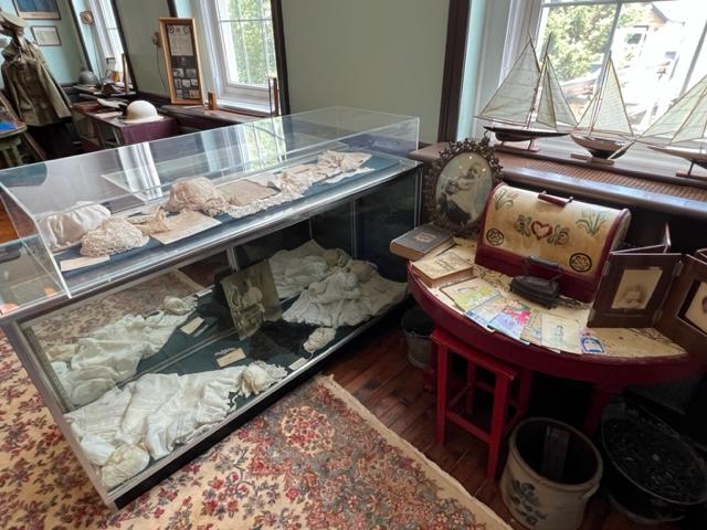
Baby clothes and household items

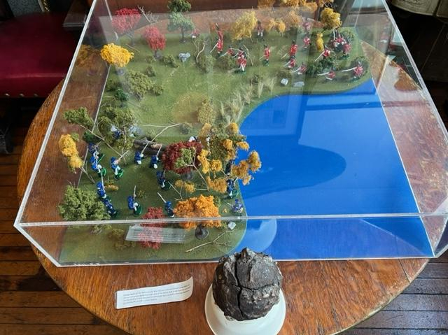
A cannonball from the Revolutionary War battle

Church Chairs in the Community Room

In the School Room, the concentration was on PS 17, which the museum is now housed in and its history with all the classroom group shot pictures, graduation pictures and a small classroom set up. There were more records and event items of the current PS 175, which is the K-8 school that the residents attend. There were also records and pictures of St. Mary, Star of the Sea School, the former Catholic school that used to be on the island as well.

The Schoolroom Gallery

The Schoolroom Gallery

The Nautical Room needed an overall as there was too much going on in the room with pictures all over the walls, equipment for navigation and for fishing and records of the ship building companies that used to dot the island. There were boats in various shapes and sizes on display and the companies that built them like Wood Yacht, Nevins Yacht and Minneford Yacht. There was also the history of shipbuilding and sail making on the island. The tour guide told me there were no more ship builders on the island, but one sail maker left.

The Shipping making equipment

Locally made boats on City Island

The Library where all the research is done on the island and on the families and businesses that were once here was dominated by yachting pictures and nautical photography. It held all the City Island records and even the ship building plans.

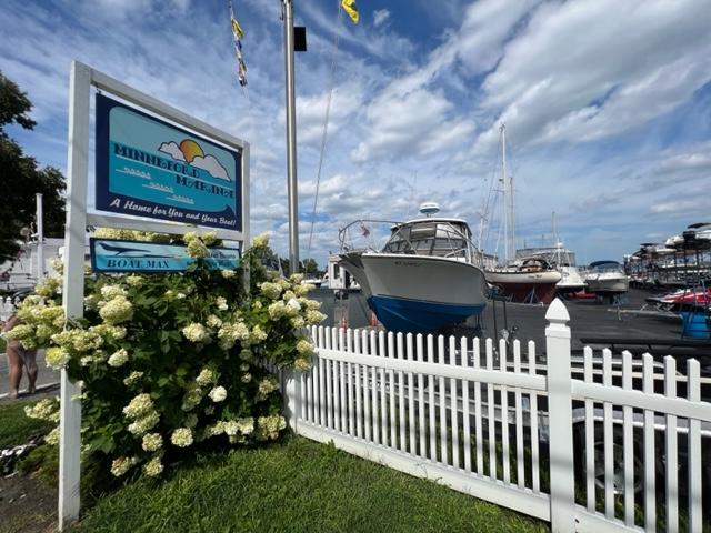
The Minneford Boatyard down the road from the museum is still operation today.

The City Island Nautical Museum Library

The museum has a lot to see but it needs to be a bit more organized to really showcase the collections properly. Still, it is one of the best museums I have seen with a nautical history theme. The best part is that you can see the whole museum in about an hour and this leaves you time to tour the island and see how the museum better explains why the island is the way it is right now.

The Ship display in the City Island Nautical Museum Library.

The History and set up of the City Island Nautical Museum:

(From the Museum pamphlet)

History of the Museum:

(From the Museum Pamphlet)

The City Island Nautical Museum is located in one of the island’s most picturesque and historic buildings, the former Public School 17, built in 1897 on one of the highest points on the island. When the residents of City Island voted in 1895 to separate from the town of Pelham in Westchester County and to become part of New York City, the City administration built the school, which continued in use until 1975. When the building was sold in 1986, the City reserved space for use by the City Island Historical Society and the Community Center and several old classrooms now serve as galleries for the museum.

The front main gallery is reserved for revolving exhibits. This exhibit that was being featured in the summer of 2023 was by local artist Liz Alderman.

The Liz Alderman Exhibit in the Front Gallery:

Local City Island Artist Liz Alderman at the City Island Nautical Museum in 2023.

The Liz Alderman Exhibit in 2023 at the museum

The Liz Alderman Exhibit of the local artist’s work.

The Liz Alderman Exhibit at the museum

The Main Hall and Gallery:

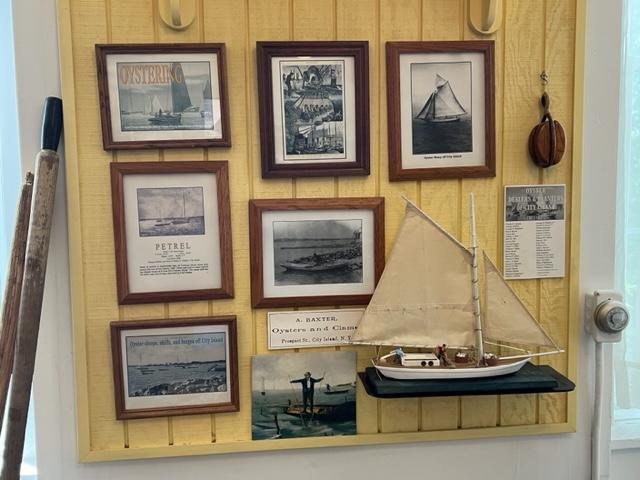
The Main Hall is lined with photographic essays featuring maps, the America’s Cup, City Island’s most beautiful boats, the City Island Bridges and historic buildings as well as a history timeline, models of a minesweeper and several rum runners, built during Prohibition and a handsome wooden kayak built in the 1930’s. The foyer contains the museum’s gift shop, featuring articles for sale such as books, t-shirts, photographs, postcards and nautical gifts and the desk where the docents greet visitors.

The Gallery features display cases with antique shipbuilding and sailmaking tools and the walls are covered with photographs of yachts built or serviced here and portraits of legendary City Islanders who contributed so much to the life and work on the island.

The Main hallway at the City Island Nautical Museum

The Walsh Library:

The recently refurbished library features a collection of books devoted to maritime history and many binders and scrapbooks featuring newspaper clippings, postcards and articles about City Island, Pelham Bay Park and Hart Island. There is an extensive selection of nautical magazines, including Yachting, Rudder, Wooden Boat and Classic Yacht, a data base of all boats built on City Island since 1848 and an impressive display of ship models. Special exhibitions regularly mounted in the library feature the work of local artists and photographs documenting aspects of City Island history.

The Library at the City Island Nautical Museum
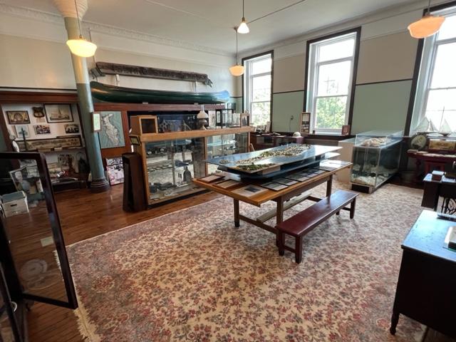
The Nautical Room:

Shipyards, sail lofts, yachts and the people behind them are all honored here. Historical photographs, memorabilia and artifacts fill the room and tell the story of City Island’s rich nautical past. Also on display are tools used by sailmakers and shipbuilders, several ship models and some vintage outboard motors. Of particular interest in the room are several skiffs, a partially completed boat and a Buchman sailing canoe from the early 1930’s (all built on City Island).

Ship building display on City Island

The Community Room:

Celebrating City Island from its earliest days, the Community Room displays photographs, maps and memorabilia, including Native American arrowheads found in the area. The walls are covered with images of street scenes, stores, restaurants, private houses, and the waterfront then and now. Displays include a large relief map of City Island in about 1867, a diorama of the Battle of Pell’s Point that took place in October 1776, a niche devoted to City Island’s religious institutions and many antique home furnishings, including sewing machines, an ice box, and a 100-year-old typewriter. A large counter from Gilbert’s Pharmacy serves as a display case in the center of the room.

The Community Room at the City Island Nautical Museum

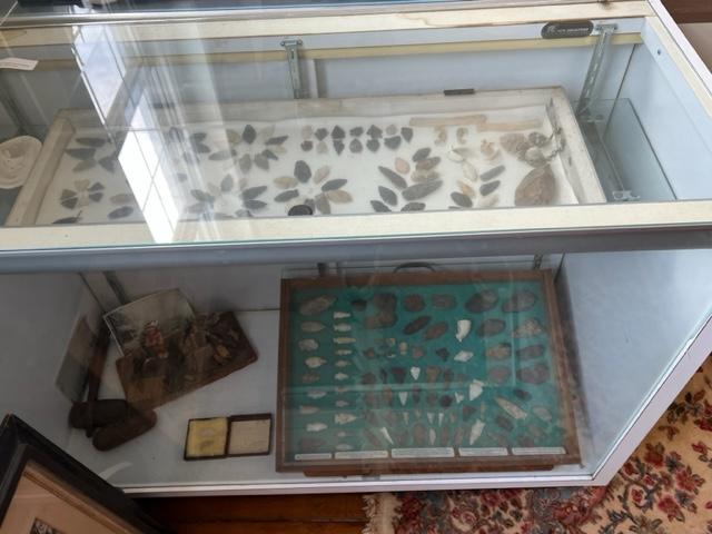
The Native American Collection in the Community Room

The School Room:

Student registers, graduation pictures, autograph books, report cards, the old school bell, and the other artifacts tell the story of City Island’s schools from the first schoolhouse built in 1838 to the present school, P.S. 175, built in 1975 and St. Mary, Star of the Sea RC School, which served the island for over 75 years. A section of the room is set up like a traditional school room, and a unique map of the naval training station that was located in Pelham Bay Park from 1917 to 1918 hangs on the wall.

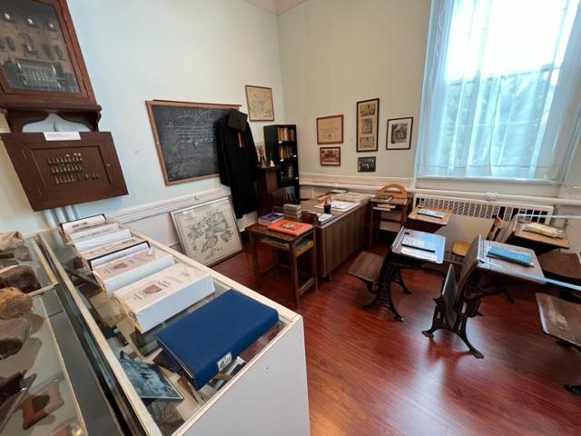
The classroom set up in The School Room

Day Two Hundred and Forty Visiting the Historical Sites of Southern New Jersey in Cumberland, Cape May and Salem Counties-A Local Journey on Father’s Day Weekend                                                             June 18th-19th, 2022

Day Two Hundred and Forty Visiting the Historical Sites of Southern New Jersey in Cumberland, Cape May and Salem Counties-A Local Journey on Father’s Day Weekend June 18th-19th, 2022

Grab your tour book and get in the car to visit all these wonderful sites. There is so much to see and do in Historical Southern New Jersey!

The Salem Historical Society

The Salem Fire Museum

jwatrel's avatarmywalkinmanhattan

The one thing I refuse to do on Father’s Day is to spend the day at the cemetery. I know that is some people’s idea of honoring one’s family members but it is not mine. I went on Friday and paid my respects to my father (whom this blog is dedicated to) and spent time remembering some of the good times we had in past. I dropped some cut flowers from our gardens (some of which he planted) and said a small prayer. Then I left.

My idea of honoring my father and spending Father’s Day with him is to do something that we would have shared together. We were always running around somewhere and exploring something new and doing something fun. That is how I wanted to honor him. By being active and giving him a toast at Sunday dinner.

I had gotten a pamphlet on the historical sites…

View original post 8,238 more words

Fort Mott State Park                                                                454 Fort Mott Road                                                                Pennsville, NJ 08070

Fort Mott State Park 454 Fort Mott Road Pennsville, NJ 08070

Fort Mott State Park

454 Fort Mott Road

Pennsville, NJ 08070

(856) 935-3218

https://www.nj.gov/dep/parksandforests/parks/fortmottstatepark.html

https://www.facebook.com/FortMott

Open: Sunday-Saturday 8:00am-7:30pm/Please see their website for seasonal hours

Admission: Free

My review on TripAdvisor:

https://www.tripadvisor.com/Attraction_Review-g46726-d6775079-Reviews-Fort_Mott_State_Park-Pennsville_New_Jersey.html

After touring Finns Point Lighthouse in the front of the park, I drove to the back of Fort Mott State Park to tour the rest of the park and explore the old fort. Talk about a real surprise and a a real treat. Talk about views of the Delaware River. On a sunny afternoon, the sun really reflects off the water and makes the most amazing light show.

I walked up the Parapet, the massive concrete wall that used conceal the guns that protected the bay and the river. It was a impressive piece of construction and you could see where the guns had been mounted. You could climb up and down the stairs to get from one part to the other and enjoy the views.

The gunnery

I passed the old Western Fire Control tower that was closed for the day and open by appointment only. That must have offered some spectacular views.

The Western Fire Control Tower

I then toured the Visitors Center and saw all the artifacts from the war, a timeline of the Fort and the history of the fort. Take time to look at each case and you will see how the fort developed, the types of things used at the fort and the people who were stationed here and their stories. It also offers bathrooms.

The best part of the Fort Mott State Park is just walking around the lawn and enjoying the sunshine and river breezes on a hot day. The blue skies with the sunshine gives you a sense that it was not just a place of protection but Mother Nature lending her hand to offer a spectacular location to just stop and wonder what would it been like if something happened here during the war. Would it withstood the assault?

The best part of the park is just to walk around the lawns and enjoy the river views.

Map of Fort Mott State Park (NJ State Parks.org)

The History of Fort Mott:

(From the Fort Mott State Park Pamphlet-New Jersey Division of Parks and Forestry State Park Division)

Fort Mott, an Endicott-era fortification was built as part of the federal government’s late 19th century plan to defend the Delaware River. Today it serves as a state park where visitors can tour the remains of the historic fort. The cultural and historic features of this park and its recreational facilities provide a unique blend of activities for the park visitors.

The views from Fort Mott of the Delaware River

Fort Mott State Park is included as a point of interest on the New Jersey Coastal Heritage Trail. A Welcome Center for the trail accommodates displays defining Fort Mott’s place in history and the maritime environment. Fort Mott State Park is on the Delaware River at Finn’s Point in Salem County, New Jersey. This 104-acre park is six miles south of the Delaware River Memorial Bridge, off New Jersey Route 49.

The Finn’s Point Reservation was purchased by the United States Government in the late 1830’s. Originally called “The Battery At Finn’s Point”, the proposed fortification was one of a three-fort plan to protect growing industries and shipping along the Delaware River. Plans for Finn’s Pint specified eleven-gun emplacements with twenty guns and a mortar battery with six complacements. With Fort Delaware on Pea Patch Island in operation since the early 1820’s and the nation involved in the Civil War, the construction of the Battery at Finn’s Point was delayed until 1872. At that time, only two-gun emplacements and five magazines in the mortar battery were completed before construction was halted due to budgetary constraints.

The headquarters buildings

With advancements in military technology made during and after the Civil War, the United States defenses were dangerously inadequate. In 1885, President Grover Cleveland, at the request of Congress, appointed the Endicott Board, named after its Chairman William Endicott, the Secretary of War. The board, which consisted of both military men and private citizens, studied the existing coastal defenses and developed a coastal defense plan for the United States. This plan determined where defenses and developed a coastal defense plan for the United States. This plan determined where defenses should be built or improved, the order in which the work would proceed, the quantity and type of guns that would be placed at each fort and other considerations.

The signage

The main defense concept of the Delaware River was dispersion of armaments into three separate fortifications. The original plan for the Battery at Finn’s Point was abandoned and construction of new fortifications began in 1896 in anticipation of war with Spain, the Spanish-American War. This fortification was officially renamed Fort Mott on December 16th, 1897, to honor Major General Gershom Mott. Mott, a native of Bordentown, NJ was a decorated veteran of the Mexican American and Civil Wars. Fort Delaware was upgraded, and construction of Fort DuPont began during this same time period.

The signage

At Fort Mott, large caliber weapons, three 10 inch and three 12-inch guns were installed on disappearing carriages. The gun emplacements were located behind a 750 foot long and 35-foot-thick concrete and earthen embankment, which was sloped to form the ‘parapet’ wall. These guns had an effective range of seven to eight miles and shot projectiles that weighed 617 and 1000 pounds respectively. Beneath the six-gun platforms were powder and shell magazines, ammunition hoists, a telecommunications system and an electric generating station. Two batteries each with 5-inch rapid fire guns and one battery with two 3-inch rapid fire guns were also part of the defenses, designed to counter fast moving smaller warships which might evade the large caliber guns. They also protected the fort from potential land attack. Fort Mott was a completely modern installation for its time period.

The Fort Mott headquarters

Two steel control towers were later built to improve aiming of the guns. Observers stationed in the towers, in conjunction with plotting room personnel, directed the gunfire of the 10 inch and 12 inch guns. The tower near the river on the northern end of the emplacement was built in 1902 and was used to aim the 12 inch guns of Battery Arnold. The tower near the park office was built in 1903 to help aim the 10 inch guns of Battery Harker.

Behind the main emplacement are the parados and the moat. ‘Parados’ is Spanish for rear door. These provided the rear defenses for the fort. The parados was constructed using the fill from the moat. Landscaping around the military reservation helped camouflage Fort Mott from attack by potential enemy ships.

Fort Mott was self-contained military community. The post had over 30 buildings, including two large barracks, non-commissioned and officer’s housing, a hospital, a post exchange, a library, a guard house, a stable, YMCA and a school for the soldier’s children. The Delaware River was the main transporation infrastructure for Fort Mott; munitions, supplies and construction materials arrived at the fort by barge.

WIth the construction of Fort Salisbury near Milford, Delaware shortly before WWI, Fort Mott, Fort Delaware and Fort DuPont became obsolete. The three forts remained active defense installations until after WWII, when they were phased out. Troops were regularly stationed at Fort Mott from 1897 to 1922. The federal government maintained a caretaking detrachment at the fort from 1922 to 1943. During this time, Fort Mott’s guns were dismantled and sent to various locations.

Visiting Fort Mott

Fort Mott was declared “surplus property” in 1943. Finn’s Point National Cemetery (dedicated a National Cemetery on October 3rd, 1873 because of the Confederate prisoners of war buried there) was separated from Fort Mott at that time. In 1947, the State of New Jersey purchased Fort Mott, as a historic site from the federal government. On June 24th, 1951, it was opened to the public as Fort Mott State Park.

Finns Point Lighthouse                                                          Fort Mott & Lighthouse Roads                                   Pennsville, NJ 08070

Finns Point Lighthouse Fort Mott & Lighthouse Roads Pennsville, NJ 08070

Finns Point Lighthouse

Fort Mott & Lighthouse Roads

Pennsville, NJ 08070

(856) 935-3218

https://www.lighthousefriends.com/light.asp?ID=374

https://en.wikipedia.org/wiki/Finns_Point_Range_Light

Hours: Sunday-Saturday (Open with Fort Mott State Park-Lighthouse Currently closed, check the website of the park)

Admission: Free when open

My review on TripAdvisor:

https://www.tripadvisor.com/Attraction_Review-g46726-d14113446-Reviews-Finns_Point_Rear_Range_Light-Pennsville_New_Jersey.html

Finns Lighthouse in Fort Mott State Park

The Finns Point Lighthouse is located in the Fort Mott State Park and the afternoon that I was there which was the third Sunday of the month of June, it was not open. In fact, it looked like it had never opened for the day.

The gift shop/information center had a sign from 2019 with the hours of operation and the steps were not well cared for and the gardens around the building were over-grown. The lighthouse itself is behind a fence that you can look at but not enter and from what I read online is not open even when it should be if it is too hot or too cold because conditions inside can be impossible. The lighthouse and the Visitors Center will reopen for the 2023 season.

The Finns Lighthouse Visitors Center is now open in 2023

Still, the lighthouse has a majestic look to it and must have some views when it is open. If it is not open, take time to visit Fort Mott and the State Park, which offers spectacular views of Delaware Bay and the surrounding grounds. Take time to explore the fort and the where the guns were mounted. Very interesting.

Fort Mott also has a very good Visitors Center and small museum inside to see the history of the fort, artifacts from the fort and from the war years and all sorts of interesting information on the area.

The Finns Point Lighthouse

The History of the Finns Point Lighthouse”

(From the Friends of the Finns Point Lighthouse website-modified):

https://www.lighthousefriends.com/light.asp?ID=374

(Please read the above Friends Website for the complete history in detail of the ligthouse)

Soon after the 1638 landing of the Finnish colonists near the present site of Wilmington, DE, a small group of settlers crossed over to the east bank of Delaware River, where the land was though to be more fertile and established farms. One group selected land near the sweeping turn in the Delaware River and this area remains known to this day as Finns Point.

By an act of Congress in 1875, $55,000 was set apart for two pairs of range lights to help vessels transition from Delaware Bay into the Delaware River. Port Penn Range, located in Delaware, would guide traffic along the shipping channel from Ship John Shoal to Ready Island, while Finns Point Range would help vessels continue upriver, passing between Reedy Island and Baker Shoal.

Lt. Colonel William F. Reynolds of the U.S. Corps of Engineers oversaw construction of the front and rear range lights at Finns Point. The front light was located near the banks of the Delaware River and was displayed from a frame dwelling of the following description: “one and one half stories high with shingle roof, double weather-boarded on outside and lathed and plastered inside. Its rests on stone walls founded on wooden piles. The first story is divided into three rooms with the hall and stairways to the second floor and cellar and shed over the back door, porch and bay window in the front. The second story is divided similarly to the first, with a step ladder to lantern on the third floor, a gallery supported by brackets surrounds the lantern on front and sides.”

The illuminating apparatus for the front light was a fourth order range lens manufactured by Barbier & Fenestre in Paris, which focused the light from a fourth-order Funk Heap Lamp with one wick. In 1882, a “wooden screen painted white, with open spaces so as to show horizontal stripes” was placed atop the front lighthouse’s red tavern room to make the structure more conspicuous during the day. The daymark was removed in 1897.

The lighthouse sign

Three acres of land, roughly one and a half miles inland from the front light, were purchased from Joshua and Mary Dickinson on April 20th, 1876, as the site for the rear range light. To provide a focal plane higher than that of the front light, the project plans called for a tall, wrought iron tower to be used for displaying the rear light. The Kellogg Bridge Company of Buffalo, NY was contracted to manufacture the components of the wrought tower, which were then transported to Salem, NJ by railcar. From Salem, teams of mules pulled large wagons loaded with pieces of the iron tower to the construction site.

A frame keeper’s dwelling was built just west of the tower, along with a wood-framed privy and an oil house. The first keeper of Finns Point Rear Range Light was Edward Dickerson, who started serving on December 8th, 1876, even though the light was not lit until April 2nd, 1877.

The lighthouse sign

Fast forward to the 1970’s when the old dwelling was razed because it was unsafe, but locals showed an interesting in the lighthouse and having it moved. Resident Betty Husarik formed the “Save the Lighthouse Committee”. They faulted in moving the lighthouse but placed it on the National Register of Historic Sites in 1978.

In 1981, the committee set out to Washington DC to meet with their local congressman and the drive resulted in a contract for $33,600 being signed between the US Fish and Wildlife Service, on whose land the tower now stood and K & K Painting Company of Baltimore to have the tower repairs, sandblasted and painted. An open house was held at the tower on October 14th, 1984 to honor the determined effort shown by the “Save the Lighthouse Committee” and others in restoring the tower.

Today it is opened for limited tours and special events.