The Stone Harbor Bird Sanctuary is a wonderfully preserved microcosm of what the barrier islands of New Jersey looked like hundreds of years ago. As you walk along Sanctuary paths, it is easy to imagine the Lenni-Lenape Indians wandering through the maritime forest, crossing wind swept sand dunes, past groves of white cedar, birch, pine, holly and sassafras trees, taking time to drink water from a spring fed freshwater pond and then, fishing in the salt water meadows surrounded by herons and songbirds.
As early as the 1870’s and 1880’s, the Sanctuary area was recognized as a “veritable paradise of birds” for ornithologists. The primary attractions were Little Blue Herons, Black-crowned Night Herons, Green Herons and egrets. Once the 96th Street Bridge opened in 1911, those who wanted to study, hunt or collect the eggs of birds no longer had to walk across four miles of marsh. Easy access to the heronry was a boon to birders but also a threat to birds whose plumes and eggs were valued.
In 1941, the Stone Harbor Bird Club was organized in the home of Lillian R. Leuallen. The Bird Club was renamed in 1946 as the Witmer Stone Club to honor Witmer Stone, one of the first ornithologists to document birds in the Sanctuary area. With considerable foresight, the Witmer Stone Club proposed early in 1947 that the Borough of Stone Harbor establish a “sanctuary”. In October of 1947, the Borough Council passed Ordinance #208 which preserved 31 acres of land as a wildlife sanctuary. Subsequent to expert study in 1961 which demonstrated that no birds were nesting on the beach side sanctuary acreage, the Stone Harbor Borough Council sold ten acres to the east of Second Avenue. The remaining 21 acres bounded by Second Avenue to the East, Third Avenue to the West, 111th Street to the North and area between 116th and 117th on the South represents the Sanctuary as we know it today. The Sanctuary remains one of the few bird sanctuaries in the world that are completely within municipal boundaries.
One can’t overstate the foresight and commitment of the residents and Borough officials to conservation as well as the preservation of open space and wildlife in 1947, 1961 and every year since. This commitment was reinforced by the United States Park Service in 1965 when it designated the Sanctuary as a National Natural Landmark.
Over the years, the Sanctuary has been home to thousands of birds and visited by more than a million people representing all fifty states and most countries in the world. It has been estimated that Sanctuary visitors spend more than $5 million each year, locally. Although some like the New York Times in 1960 glorify the Sanctuary, referring to it as “The Everglades of New Jersey”, Stone Harbor residents think of the Sanctuary as a symbol of the character of this quiet, single family town which respects the nature and wildlife that surrounds them while placing a premium on livability, aesthetics and serenity.
The front of the sanctuary from 3rd Avenue
I took a walk when I was in Stone Harbor through the town’s Bird Sanctuary to hopefully view some rare birds. While I did not see much, I heard a lot of singing and scrawling as I walked the path through the trees.
The front gardens in the sanctuary
The gardens were still in bloom in the late Summer and many colorful wildflowers attracted all sorts of butterflies and other insects.
The sign greeting you about the experience
The front path of the sanctuary
You head over the bridge to the paths that take you into the woods
Walking down the pathways through the woods
The path takes you into a deep wooded area in the middle of the town and by the time you get to the middle of the path, you can hear the mating calls of many birds. It’s funny to note that we are a couple of blocks from the shore.
Walking through the pathways
Reaching the middle of the beach woods
The middle of the bird sanctuary noisy with bird calls
Walking back through the pathways through the roads
Touring through the Bird Sanctuary does not take a long time, but offers relief from a busy shore town.
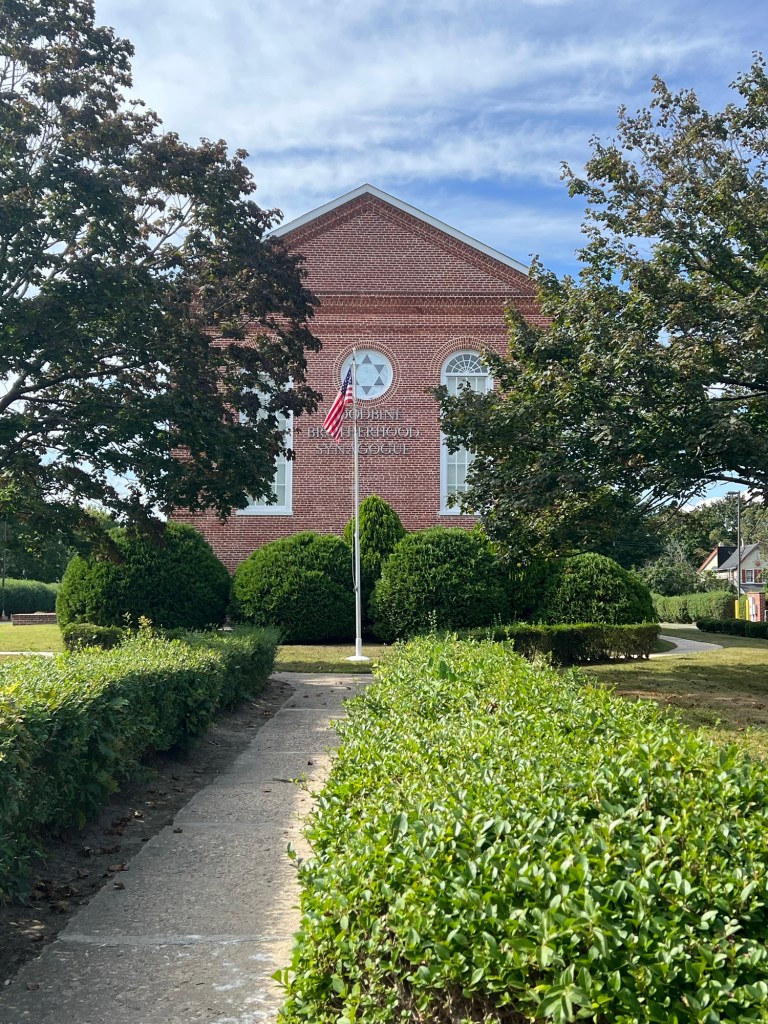
The front of the Sam Azeez Museum of Woodbine Heritage
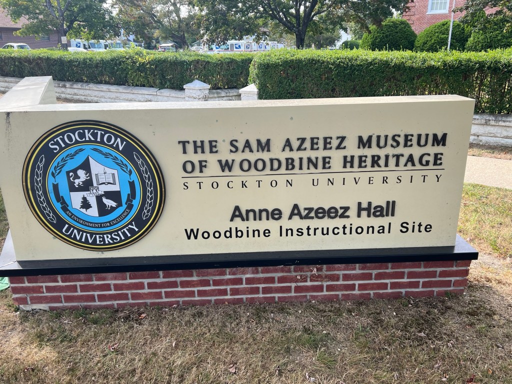
The entrance sign that welcomes you
The History of the Sam Azzez Woodbine Museum:
(from the museum’s website):
The Sam Azeez Museum of Woodbine Heritage is an independent non-profit charitable organization preserving the unique history of Woodbine, NJ.
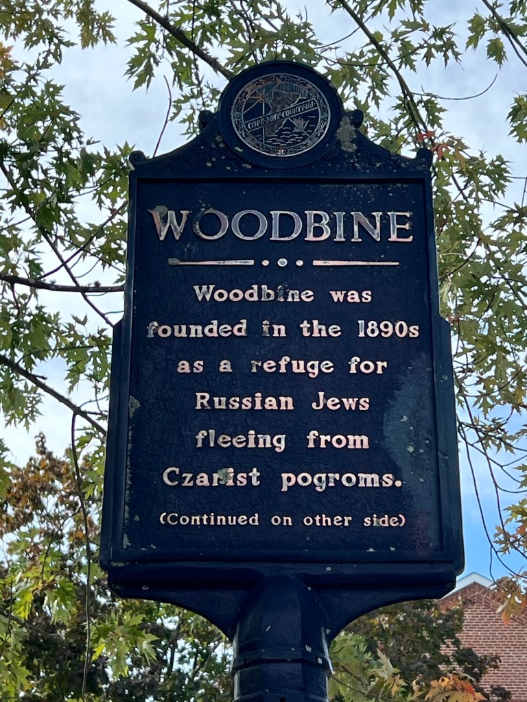
Established in the 1890’s through Baron de Hirsch’s philanthropy, Woodbine began as an agricultural colony for Russian Jewish immigrants seeking freedom denied in their homeland. As poor soil conditions limited farming, Woodbine evolved into Cape May County’s manufacturing center while maintaining founding values of education, religion and inclusion.
The museum occupies the historic Woodbine Brotherhood Synagogue, listed on the Natural Register of Historic Places. The restored sanctuary hosts special services, while the Brotherhood Hall houses exhibitions including the community-contributed Collective Memory Wall.
The historical significance of of the Town of Woodbine
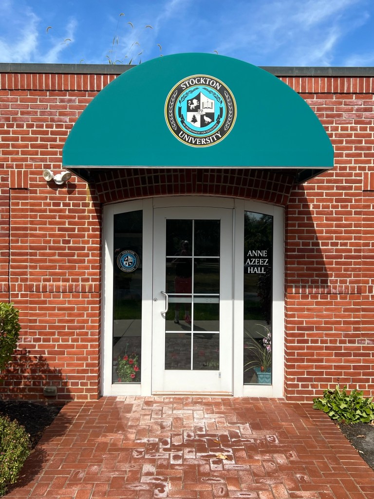
The entrance to the museum
The museum is another interesting look at New Jersey history and the development of the immigrant story of assimilation into American society.
I was given a personal tour by the Assistant Curator and she explained the resettlement of Russian Jewish immigrants by a wealthy patron into this South Jersey community.
The main gallery of the museum
The panels tell the story of how these community came into being and how these people built a community through agricultural and eventually manufacturing and small businesses that supported the community around it. It established a town that was self sustaining and grew to the community center.
The panels show the growth of Woodbine as a community
The residents established their own sports teams, community organizations and civic groups like the councils and fire and police departments.
The records of the many town organizations of Woodbine
Display of one of the first families to settle in Woodbine
Display of the religious faith of the community
One of the most touching displays is of survivors of the concentration camps during the holocaust. These pictures represent these women as children and them today.
The display of the women who survived the camps
The history of the community and the growth of diverse businesses in Woodbine
Creating and building the Synagogue in the community
On the second floor of the building is the old synagogue of the community which is only used during the high holidays. This is used by descendants of the community and family members of theirs.
The inside of the synagogue on the second floor of the building
The front of the temple
The chandelier is original to the temple
The space was being prepared for the Jewish New Year and the crowd of people who would be attending.
The Memorial Wall
The traditions of the religion being practiced in the community
The self-government of the community
Still the younger generation was all American and wanted to assimilate into society with an all American past time of things like baseball.
The Woodbine youth baseball team
The uniform of the old baseball team for youths in the town
The last display is of the famous alumni who once lived in the community. These are the men and women who once lived here and went on after all odds to do great things and make our country better.
The Hall of Fame
The museum I thought had a bit of an identity crisis as I really did not know what the museum was about.
I was pleasantly surprised to find an interesting part of New Jersey history I had never known. It just goes to show you how a museum can educate you with just one visit. The Assistant curator said there will be more to come in the future.
Open: Please call for a appointment and special tour
My review on TripAdvisor:
The front of the schoolhouse
The entrance to the property
The historic marker
The outside sign
The Friendship School was an interesting look at early rural education where students of various ages would be educated together.
The hours would vary with the growing seasons and students would be educated in the basics to educate them to the next level.
During the school day, children would have various chores to do such as gather wood, collect water, mind the fire and watch the day’s lunch. It would be a full day for both the teacher and the students.
My tour guide confirmed that nothing was easy during the school day and children had a lot of responsibility for what went on in their lives.
The tour was an interesting look at the lives of children of that period of time and the education they received.
The history of the Friendship School:
(from the Museum’s website)
This historic property contains the circa 1930 Friendship School, a circa 1900 privy, and a circa 1917 coal storage shed. The Friendship School was originally donated in 1976 by William Wells, grandson of Enoch Clouting to the Upper Township Bicentennial Committee during a time when Upper Township was particularly interested in its earliest buildings.
The historic plaques
The school’s hand pump
The committee, headed by the late Curtis T. Cordon, evolved to become the nucleus of the Historical Preservation Society of Upper Township (HPSUT) in 1977. Virginia M. Wilson was its’ first President.
The history of the Friendship School begins when it was incorporated in May of 1831 with Jonathon Corson, Lewis Corson, and Seth Young as trustees. The students’ tuition was paid for by parents in 1830, but by 1869, public funding for schools was established. In the 1862-63 school year, 52 students crowded into this 15’x 20’ structure, and of those students in the teacher’s roll book, 24 were Corsons!
The grounds of the school grounds
The school itself is standing on its fourth known location! It was originally located 6 houses southeast of its present location. It was used for classes until it was replaced with a larger building in the 1860’s.
The abandoned school house later owned by resident, Lot Corson, became known as “Lot’s Temple” because church services were held there. Then, it was moved to Enoch Clouting’s farm where a corn crib was placed on one side. It is Enoch’s grandson who kindly donated the school.
The barn on the grounds
The school building was in extreme disrepair when it was moved from the Clouting property to the corner of Ocean Ave. and Shore Road. According to an undated news article, “mere fragments of the (original) building remained” although “some of the heavier corner posts were salvaged.”
The school’s outhouse (pricey)
The historic sign
Nevertheless, restoration of this Friendship School was researched and planned by Kyle Fleetwood of Tuckahoe and James Wilson of Marmora; with assistance from Matt Unsworth, Robert Entirkin, Curtis Corson III, Somers Corson, Marshall “Ted” Behr, Guy Himmelberger, Harry “Hap” Folger and other members of the Bicentennial Committee. It was completed in 1980.
All replacement wood matched the original in size and material and great care was taken to restore it to its original appearance. Locally sourced materials for the restoration/reconstruction came from the Van Vorst sawmill in Petersburg, the Hess sawmill in South Seaville and the Brewer sawmill in Dennisville. Benches donated by Myra Clouting Biggs, were reproduced by Matt Unsworth.
The inside of the school house
The teacher’s desk is a reproduction also made by Matt Unsworth. Hardware for the building was hand-wrought by Robert Entrikin of Petersburg. Although it does not qualify for the State and National Registers listing because it retains little original historic building fabric, the building is important to the historical time line of Upper Township.
The schoolbooks and school equipment
Also on this site are two old frame buildings: a circa 1900 privy donated from the property of the Seaville School on Kruk Drive and a circa 1917 coal/storage shed donated from the Palermo School on Route 9. The coal storage shed, was donated by Wes and Doris Nickerson with Jim and Nancy Siegrist helping with its restoration. It was added to the property in 1993. Three three-seat privy (outhouse) from the old unused Seaville School was donated by Sharon Kruk in honor of her father, and was restored by Lewis Albrecht and Jim Siegrist. It is a work of art (with a French style roof), but is non-functional.
The school room reproduction
A special item, the cedar flag pole, from which flew a U.S. flag that flew above the capitol in Washington, DC, was donated by former Deauville Inn owners, Walter and Gloria Carpenter in December of 1983. (Since replaced)
The school bell and flag
The Friendship School was dedicated on September 10, 1983 by Virginia M. Wilson, President of the Historical Preservation Society of Upper Township, Upper Township Mayor Leonard Migliaccio, HPSUT members: Ebbie Unsworth and her son, Matt Unsworth, and guest speaker, New Jersey State Senator, James R. Hurley.
The children would collect water and fire wood for the class room during the school day
The reproduction of the school
Upper Township continues to own and manage the property and the school, while HPSUT members manage the inside and its activities. Each Upper Township Kindergarten class is invited to the annual Kindergarten Day to learn what a student classroom life is like in a one room school house in the early
Welcome to Bergecco-Parc Consulting Inc. from Professor Justin Watrel, CEO & Co-Founder:
“This is the second time I have opened the firm, Bergecco-Parc Consulting Inc., for my Introduction to Business 101 class. As a College Professor, I have always felt that the only way that the students are going to learn is by doing the work in real life. So every semester we do a group project that encompasses everything we are learning in the text book. The entire class becomes members of the Paramus-branch Team and they have to do a real life project that has to be presented in front of a group. This project took it one step further as the Team was invited to present the project to His Honorable Andre Sayegh, Mayor of Paterson and his Executive Team.”
The website for Bergecco-Parc Consulting Incorporated’s latest project: “Take me back to Paterson, NJ”:
For this semester, I developed something different from the previous projects. I had been in Paterson, NJ visiting some sites for my blog, “VisitingaMuseum.com” that is available on WordPress.com as well, that is an off-shoot of my main blog, “MywalkinManhattan.com”.
I had visited the Paterson Museum one afternoon and then walked to the Paterson Falls, which is the second highest Falls east of the Mississippi. Along the way I had a hot dog and fries at Libby’s Lunch, a restaurant that has been in Paterson since 1936 (See my review on TripAdvisor-Now closed in 2021).
The Paterson Museum at 2 Market Street
Inside the Paterson Museum
While I was walking around the Falls after lunch and admiring them for all directions, I wondered why people don’t come down and visit them.
The Paterson Falls in the Summer
Paterson, NJ does not have the best reputation in the State of New Jersey. The schools, the gang problems and the poverty rate does not add to the reputation of a city that has been left behind. It was once the shopping and entertainment mecca from the end of the
Second World War until the riots of 1967. ‘
White flight’ and the closing of manufacturing plants sealed the fate of the city and the 1991 fire of Meyer Brothers Department Store in the downtown area just personified the problems of the City.
Downtown Paterson, NJ
The former Quackenbush Department Store
Yet I still saw something there. There is a lot of beauty to the City. Walking from the Falls back to the Paterson Museum I decided to find Lou Costello Park, a small square that is dedicated to the Comedian Lou Costello of the comedy team of Abbott & Costello. This small park just down the street from the Falls and was weed investing and full of homeless people. It was a little scary walking through the park, more for the homeless than for me as they thought I was an undercover policeman.
Lou Costello Memorial Park
The park in the summer
Walking down the street from the park leads to “Little Lima” the home of one of the largest population of Peruvian-Americans in the county. This vibrant neighborhood contains restaurants, retail stores, bakeries and salons and there is a lot to offer. This was once home to a large Irish population who used to work in the Mills and then it was Paterson’s Italian “Little Italy” until about the 70’s when most families moved to the suburbs.
Little Lima in Paterson, NJ
I stopped in Los Immortales at 21 Market Street, a deli/bakery (see review on TripAdvisor) for a snack. They had the most delicious dulce de leche doughnuts, filled with a kind of caramel tasting sweetened milk filling. They also had delicious pastilitos, similar to empanadas, a pastry filled with beef or chicken.
Los Inmortales at 21 Market Street
On another trip I made to the City later that week to finalize the field trip, I ate at Central City Pizza at 301 Main Street (see my review on TripAdvisor). Their pizza was amazing for a small pizzeria. The slices were huge, the pizza sauce amazing and at $2.00 a slice was well within budget.
All of these sites were only within a few blocks of one another. As I was walking back to the car at the museum, it dawned on me why people were not coming here with these free cultural sites and reasonable meals. This is where the idea for marketing Paterson, NJ for tourism came about.
The front of the Paterson Museum
The front of the museum
This semester I wanted to introduce my business students to the concept of marketing and using their business tools from class to see the same vision of the City that I was seeing. So I presented the project, “Take me back to Paterson, NJ”, to the class. How could we take the second largest City in New Jersey, one that was surround by some of the wealthiest suburbs and make it a destination to travel to for entertainment?
Our logo promoting the City of Paterson, NJ
Another proposal on the logo for the City
What I like about working with students in the entry level classes is their eagerness to look at things in a new light and their ambition to push themselves on their own. When I set the Executive Team up, it was interesting to see how they all come together. It takes time but I always see new relationships and friendships come out of it.
Walking through ‘Little Lima’, the Peruvian section of the City of Paterson
It was a slow start on the project as the students had to get to know their groups and the trust factors start. I saw the project start to jell when I arranged a trip ‘into the field’ to Paterson, NJ after our Midterm exam. I was surprised how happy some of the students were to go on a field trip. We lucked out and the weather was terrific, warm and sunny, a perfect fall day.
Our trip to the falls really amazed them
The interesting part of this trip I found out later on in their research papers on the project was that many of them were worried about visiting Paterson, NJ. The reputation was already established in their minds and it was my job as their CEO of the company to change it.
As a group, it was an information trip and I could tell really opened the eyes of the students. Not only were they really surprised by what they saw but I liked how they bonded together both over lunch at Libby’s for a hot dog and fries and touring the Falls for a second time.
We started the trip by visiting the Paterson Museum first and meeting the curator and staff. I don’t think the students realized what a rich history Paterson had and the role it played in the history of this country. The Paterson Museum covers from the time of the Lenape Indians when they used this area as a fishing site and for worship to when Alexander Hamilton created the first planned City using the water source as energy and this lead to the creation of the Silk Industry henceforth the nickname “Silk City “.
The Museum covers the history of the City of Paterson including famous individuals such as Lou Costello the Comedian, the growth the aerospace business of Curtis-Wright, the gun manufacturing industry, the silk industry and locomotive industry. There is also displays of minerals from the area as well as art work. Some of the students from our Talent Division had to plan a press party here so they asked lots of questions.
The history of ‘Silk City’ at the Paterson Museum
Touring the museum
After our tour of the Paterson Museum, we started our first part of the tour of the Paterson Falls before lunch. Since the day got clearer and sunnier, the Falls were in their prime. It was just beautiful to enter the Paterson Falls National Park.
The Paterson Great Falls in the Great Falls District of the City of Paterson at 72 McBride Avenue
This is where the students were able to capture of the real beauty of the City. The Falls were just beautiful with all the leaves changing colors behind them. We saw the entrance to the park for a quick explanation of the Falls and how they developed and how the Indians used this area as their summer camp.
The Paterson Falls
Before we took a full tour of the Falls, I took the students to Libby’s Lunch at 98 McBride Avenue (See review on TripAdvisor-Closed in 2020), a small diner restaurant that has been by the Falls since 1936. We had a group lunch of hot dogs and French fries (some of the students had turkey burgers) and Cokes. This is where I really saw my students bond. There was a lot of laughing and talking around the table and I could see that everyone was having a good time. The service could not have been nicer and more friendly and our waitress handled this large crowd well.
Libby’s Lunch in Paterson, NJ at 98 McBride Avenue (Closed in 2020-now Silk City Cafe)
After lunch, some of the students had to leave for work and other classes (they would return later for future visits) and the rest of the class and I continued on with our tour of the falls. We walked from the restaurant to the top part of the river and walked over the bridge covering the Falls and then we walked over the Falls. That’s when I knew I had their attention. The Falls are just so majestic and natural that when you hear the roar of the Falls it is enjoyable.
The hot dogs and fries were terrific
I gave the students about twenty minutes to walk around the park and just admire the view. I could see that many of the them were captured by the beauty of the park and after walking all over the park, some of them met on the benches below and just talked. it was nice to see that they were getting along so well.
Our next stop was Lou Costello Park, a tiny triangle of land down the block from the Falls and into the Mill district. This small park was dedicated to the famous comedian is located just behind the ‘Little Lima’ neighborhood District just off Ellison Street.
Lou Costello Park on Van Houten Street
The information sign in the park
It is a sad reminder of the famous comedian. The park was falling apart and I had to warn the students of the homeless who took up residence here. For the most part, our group seemed to scare away everyone and we were able to walk the whole park with no problems. The statue could have used a good sandblasting and the lawn a good mowing and trimming but overall it was a good tour. There were not a lot of homeless that day in the bandstand.
Our next part of the tour was to “Little Lima’, the Peruvian-American district of shops, bakeries and restaurants that is tucked between Downtown Paterson and the Paterson Museum. Little Lima is between Main Street, Spruce Street, McBride Avenue, Cianci Street and Ward and Olive Streets. The border is with the Paterson Museum.
We walked all the streets in the neighborhood and on the edge of Downtown Paterson, where I showed the students all the Beaux-Arts buildings that once made up all the upscale department and specialty stores, office buildings and hotels. The one thing our little group did was shock all the merchants and patrons who looked at us like “Oh, no gentrifiers!” If I saw a mixed combination of students and a professor walking through my neighborhood, I would think the same thing.
Walking down Market Street in Paterson, NJ once the shopping hub of North Jersey
We walked all the side blocks so that I could show them the businesses that were open and the condition of the neighborhood. We walked all around the church area and parking lot for a view of where we could hold events. Then I took them to Los Immortales at 21 Market Street (see my review on TripAdvisor) for dessert. We had the most delicious doughnuts filled with dulce de leche that I had eaten a few weeks before and cookies filled with the same. Each of the students took time to walk in and check out the store. Some even bought pastiletos, a type of empanada even after the big lunch. We really wiped out their baked goods. The staff got a kick out of it.
Los Immortales at 71 Market Street in Paterson, NJ
We walked back to the Paterson Museum and ate our dessert outside on the benches. We discussed the day and then the next group of students had to leave for classes and work and the last group of us headed to Lambert Castle.
Lambert Castle is located away from the downtown and we had to go to Garret Mountain Reserve Park to visit the former mansion of silk baron, Catholina Lambert. The home was closed as it was getting ready for the annual bazaar and then after the holidays it would close for a five-year renovation.
We got to walk the grounds and admire the castle with its spectacular views of Paterson and New York City plus the glorious foliage that surrounded the house and the hillside. We got to walk the fountains and walkways around the house and discussed how this could be used for parties and get togethers. From there, we finished our visit and now it was up to the students to work their magic.
From that afternoon on until the presentation on November 22nd, we met at the end of class to have Board Meetings and group discussions on our progress. Some of groups gelled better than others and with each class that I have done this there are always the ones who think they don’t have to do anything. They always stand out in the crowd.
Then there was a weird twist to the project. I stopped in City Hall in Paterson to see the Mayor and drop off a copy of the project to see if he and the Council would come and hear the presentation. Because of a mix-up in appointments, he thought I was someone else and being in a blue suit I am not sure knew who I was or what I was doing there (the intern who told me to come in was off that day and did not leave the message).
Paterson City Hall at 155 Market Street
We had a good laugh and I proceeded to tell his Honorable Andre Sayegh about our project for my class. We had a long discussion about what I wanted to do and the things I wanted the students to achieve on the project. He liked the ideas and came up with a better idea then him coming to class (he worked as a college professor as well and his class was right after mine). Why didn’t bring my class to City Hall to meet him? I loved it and told the Mayor I had to check with the school and then with the students but it should not be a problem.
The next week after our quiz and then lecture, almost everyone in my class got into their cars and off we went to Paterson City Hall on Market Street for our visit with the Mayor. I will tell you, it was a great meeting. The Mayor Sayegh is so personal and so enthusiastic about building the City of Paterson back to being an entertainment and dining destination that he embraced the project and encouraged all of my students with ideas and questions that we might have on how to bring tourists and surrounding residents back to the City.
My class and I meeting with His Honorable Mayor Andre Sayegh
With that I invited the Mayor and the Council to come to campus to hear our ‘pitch’ on how to sell the City of Paterson as a destination. He upped it more and asked if we would like to make the presentation in Paterson City Hall the morning of the project.
The class got all excited and high-fived one another. I asked everyone to slow down as permission to do this project would have to come from the Dean’s Office. I just can’t take thirty students to City Hall on a Saturday morning to present a project without permission. So with the help of my Chairman, Dean and the Vice-President of the College, we got the approval to present the project in Paterson City Hall.
I am the first one to say that I was really nervous about the presentation. I had not seen a dry run of it before that day and I found out later in the student’s papers that I read that there was a lot of last minutes preparations for the presentation up to that morning. When we got to City Hall I could see that a lot of students were nervous and when they were giving their presentations there were some that ummed their way through. This was not a problem as when you are giving your first presentation especially in a real life situation, it can be nerve wracking.
Presenting the project at Paterson City Hall
Even before the presentation I was giving the students their Dress Code grade. Getting a group of Millennials and Generation Z students to dress like it was the Reagan Administration was a challenge. Some of the men did not own suits or a blue blazer, so I allowed sweaters. Some did not know how to tie a tie but I have to admit they all had shoes that were shined. Still they presented themselves as gentlemen. The ladies were completely professionally dressed in dresses, skirts, blouses and pantsuits.
Still I opened the presentation to the Mayor of who I was as CEO, who we were and the presentation that we were about to give. After that I had the President and the Senior VP of Operations take over and what a job they did. We were working without a screen, monitor or projector that worked (surprising for a City Hall) but our President took full control of the situation and she and the Senior VP can it like pros.
Each team gave their presentation group by group. We started with the Special Events team with a presentation by their VP and her teams. We had the Lambert Castle team, The Paterson Falls Team, The Paterson Museum Team and the Abbott & Costello Film Retrospect Team. Each gave their presentation on how they would promote their areas followed by commercials promoting their section.
The Paterson Falls Team Commercial:
The Paterson Museum Team Commercial:
The Lambert Castle Team Commercial:
Then our Restaurant Team made their presentation promoting “Little Lima” as a dining and entertainment district in the way of the new “Ironbound Section” as in Newark, NJ. Our VP of the Restaurant Division also came with samples of Peruvian cookies for everyone to sample which I thought was a nice touch.
The ‘Little Lima’ Restaurant Team Commercial:
Our VP of Talent & Security and her team gave their presentation on how we were going to pay for the Paramus Division. She and her team gave their report of salaries, benefits and perks of the company. As a progressive and innovative company, Bergecco-Parc Consulting Inc. wants to keep the employees happy.
The President and Senior VP lastly gave their report on where we would be running the Division from and picked out the location in an office space in Downtown Paterson, NJ right near City Hall where we could work with the Mayor and his team.
When the students finished their presentation, I was floored by the professionalism of the project, the details and just the way the students presented themselves. I swear I thought the whole thing was really real as did the Mayor and his team.
When we opened it up for questions of the Executive Team, I enjoyed hearing how the students could justify their work and research with the field trip and then their own visits to Paterson on their own. Some of the questions got so detailed that I thought they believed this was a presentation by an outside firm. It was a great relief when it was over. The students were happy and the Mayor and his team seemed impressed.
Our last order of business was taking a picture of the Bergecco-Parc Team with the Mayor and his team. That was a thrill for me. You will never know how proud of I was of this group of students (and of all my students who do this project.
The Bergecco-Parc Consulting Inc. team Fall 2019 with his Honorable Mayor Andre Sayegh and his Executive Team at Paterson, NJ City Hall November 22, 2019.
Here is the attachment to the Bergecco-Parc Website:
The Presentation was feature in the recent “Inside Edition” of Bergen Community College Number 8:
As the team broke up and I talked with the Mayor, I saw the team leave one by one with new found respect for one another. Frustrations, concerns and last minute details over. Was the presentation 100%? There were some things we needed to work on including some dress-code issues, articulation in speeches and some of the details of the Power Point but this is what a real team faces everyday when they go to work. Who really does the work, who doesn’t, who thinks they can ‘coast by’ and who does the extra mile. I hope they all thought of this by the time we got back to class after the Thanksgiving break.
I said my goodbyes to everyone and had a quick conversation with my President and Senior VP of Operations to tell them how proud I was of the ladies for leading such a good presentation and taking control of the situation with the IT.
The only bad part is I never got to taste one of the muffins that the Mayor brought in for the team for breakfast. When I finally left, everything on the breakfast table was gone (more like stripped away).
When I came back from Florida after my break, I called the Mayor to hear his feedback and the best part was he said ‘he would hire us’. That was nice to hear!
If there was ever a Professor that felt prouder of his students it was me!