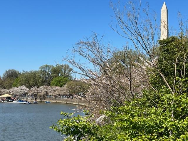
Well after seven years of trying to get to DC for the Cherry Blossom Festival I finally got down to the city to get to the tidal basin to see the display. It looks like it will be eight years as almost all the cherry blossoms disappeared almost two weeks earlier. All the leaves were long gone and as I overheard another tourist say to a friend that she was disappointed that she had not known and most of the trees were bare.
The Tidal Basin in April 2023
The festival was in its second week and most of the trees had gone green. I found out later from the Internet that they peaked on March 21st and right after that we had all that rain. It probably knocked the petals off after that.
The festival ran through April 16th, 2022 (the peak of the blooms was March 21st)
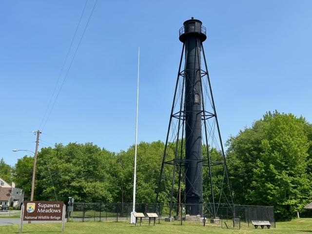
After touring Finns Point Lighthouse in the front of the park, I drove to the back of Fort Mott State Park to tour the rest of the park and explore the old fort. Talk about a real surprise and a a real treat. Talk about views of the Delaware River. On a sunny afternoon, the sun really reflects off the water and makes the most amazing light show.
I walked up the Parapet, the massive concrete wall that used conceal the guns that protected the bay and the river. It was a impressive piece of construction and you could see where the guns had been mounted. You could climb up and down the stairs to get from one part to the other and enjoy the views.
The gunnery
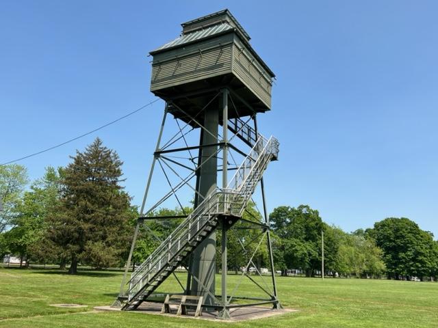
I passed the old Western Fire Control tower that was closed for the day and open by appointment only. That must have offered some spectacular views.
The Western Fire Control Tower
I then toured the Visitors Center and saw all the artifacts from the war, a timeline of the Fort and the history of the fort. Take time to look at each case and you will see how the fort developed, the types of things used at the fort and the people who were stationed here and their stories. It also offers bathrooms.
The best part of the Fort Mott State Park is just walking around the lawn and enjoying the sunshine and river breezes on a hot day. The blue skies with the sunshine gives you a sense that it was not just a place of protection but Mother Nature lending her hand to offer a spectacular location to just stop and wonder what would it been like if something happened here during the war. Would it withstood the assault?
The best part of the park is just to walk around the lawns and enjoy the river views.
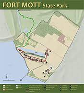
Map of Fort Mott State Park (NJ State Parks.org)
The History of Fort Mott:
(From the Fort Mott State Park Pamphlet-New Jersey Division of Parks and Forestry State Park Division)
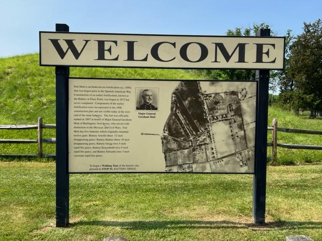
Fort Mott, an Endicott-era fortification was built as part of the federal government’s late 19th century plan to defend the Delaware River. Today it serves as a state park where visitors can tour the remains of the historic fort. The cultural and historic features of this park and its recreational facilities provide a unique blend of activities for the park visitors.
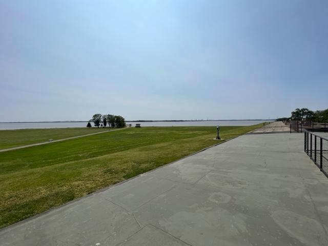
The views from Fort Mott of the Delaware River
Fort Mott State Park is included as a point of interest on the New Jersey Coastal Heritage Trail. A Welcome Center for the trail accommodates displays defining Fort Mott’s place in history and the maritime environment. Fort Mott State Park is on the Delaware River at Finn’s Point in Salem County, New Jersey. This 104-acre park is six miles south of the Delaware River Memorial Bridge, off New Jersey Route 49.
The Finn’s Point Reservation was purchased by the United States Government in the late 1830’s. Originally called “The Battery At Finn’s Point”, the proposed fortification was one of a three-fort plan to protect growing industries and shipping along the Delaware River. Plans for Finn’s Pint specified eleven-gun emplacements with twenty guns and a mortar battery with six complacements. With Fort Delaware on Pea Patch Island in operation since the early 1820’s and the nation involved in the Civil War, the construction of the Battery at Finn’s Point was delayed until 1872. At that time, only two-gun emplacements and five magazines in the mortar battery were completed before construction was halted due to budgetary constraints.
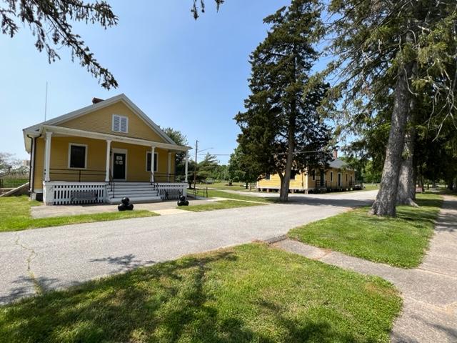
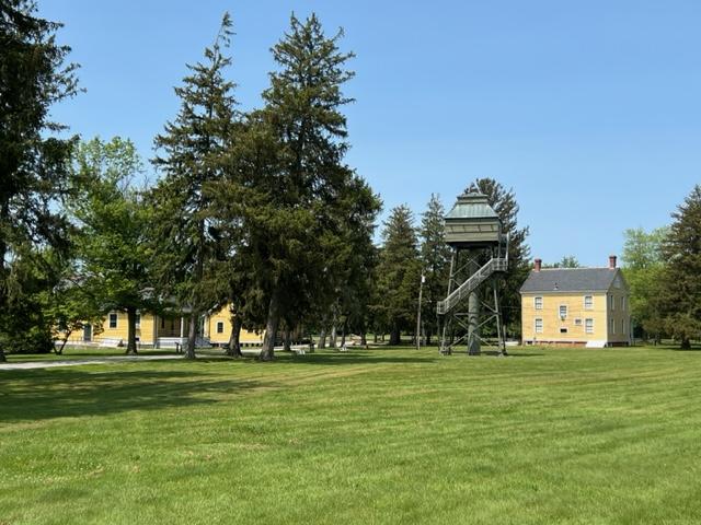
The headquarters buildings
With advancements in military technology made during and after the Civil War, the United States defenses were dangerously inadequate. In 1885, President Grover Cleveland, at the request of Congress, appointed the Endicott Board, named after its Chairman William Endicott, the Secretary of War. The board, which consisted of both military men and private citizens, studied the existing coastal defenses and developed a coastal defense plan for the United States. This plan determined where defenses and developed a coastal defense plan for the United States. This plan determined where defenses should be built or improved, the order in which the work would proceed, the quantity and type of guns that would be placed at each fort and other considerations.
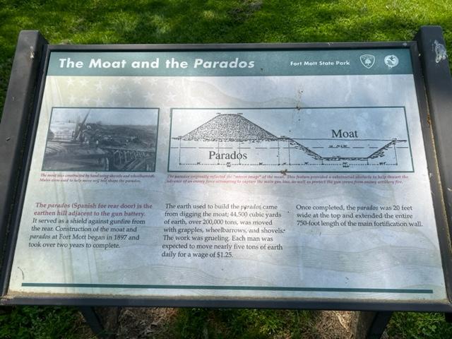
The signage
The main defense concept of the Delaware River was dispersion of armaments into three separate fortifications. The original plan for the Battery at Finn’s Point was abandoned and construction of new fortifications began in 1896 in anticipation of war with Spain, the Spanish-American War. This fortification was officially renamed Fort Mott on December 16th, 1897, to honor Major General Gershom Mott. Mott, a native of Bordentown, NJ was a decorated veteran of the Mexican American and Civil Wars. Fort Delaware was upgraded, and construction of Fort DuPont began during this same time period.
The signage
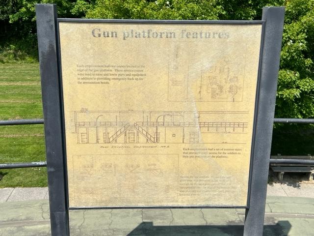
At Fort Mott, large caliber weapons, three 10 inch and three 12-inch guns were installed on disappearing carriages. The gun emplacements were located behind a 750 foot long and 35-foot-thick concrete and earthen embankment, which was sloped to form the ‘parapet’ wall. These guns had an effective range of seven to eight miles and shot projectiles that weighed 617 and 1000 pounds respectively. Beneath the six-gun platforms were powder and shell magazines, ammunition hoists, a telecommunications system and an electric generating station. Two batteries each with 5-inch rapid fire guns and one battery with two 3-inch rapid fire guns were also part of the defenses, designed to counter fast moving smaller warships which might evade the large caliber guns. They also protected the fort from potential land attack. Fort Mott was a completely modern installation for its time period.
The Fort Mott headquarters
Two steel control towers were later built to improve aiming of the guns. Observers stationed in the towers, in conjunction with plotting room personnel, directed the gunfire of the 10 inch and 12 inch guns. The tower near the river on the northern end of the emplacement was built in 1902 and was used to aim the 12 inch guns of Battery Arnold. The tower near the park office was built in 1903 to help aim the 10 inch guns of Battery Harker.
Behind the main emplacement are the parados and the moat. ‘Parados’ is Spanish for rear door. These provided the rear defenses for the fort. The parados was constructed using the fill from the moat. Landscaping around the military reservation helped camouflage Fort Mott from attack by potential enemy ships.
Fort Mott was self-contained military community. The post had over 30 buildings, including two large barracks, non-commissioned and officer’s housing, a hospital, a post exchange, a library, a guard house, a stable, YMCA and a school for the soldier’s children. The Delaware River was the main transporation infrastructure for Fort Mott; munitions, supplies and construction materials arrived at the fort by barge.
WIth the construction of Fort Salisbury near Milford, Delaware shortly before WWI, Fort Mott, Fort Delaware and Fort DuPont became obsolete. The three forts remained active defense installations until after WWII, when they were phased out. Troops were regularly stationed at Fort Mott from 1897 to 1922. The federal government maintained a caretaking detrachment at the fort from 1922 to 1943. During this time, Fort Mott’s guns were dismantled and sent to various locations.
Visiting Fort Mott
Fort Mott was declared “surplus property” in 1943. Finn’s Point National Cemetery (dedicated a National Cemetery on October 3rd, 1873 because of the Confederate prisoners of war buried there) was separated from Fort Mott at that time. In 1947, the State of New Jersey purchased Fort Mott, as a historic site from the federal government. On June 24th, 1951, it was opened to the public as Fort Mott State Park.
I put “MywalkinManhattan” on hold for a few days as the local activities in New Jersey started to take up my time. There is so much to see and do as the weather is getting warmer.
The Northwest Bergen History Coalition every year gives people the opportunity to visit almost a dozen different historical sites in the upper part of Bergen County, NJ and take the time to tour and explore all the sites with the help of trained docents and volunteers who take immense pride in showing off their site all for the low price of $10.00 ($15.00 the day of the event). Be prepared to drive though because all the sites can be a distance from one another. Also, have a a game plan because there is no way you can see everything in one day. You will only have from 10:00am-4:00pm so plan to visit the remaining…
On the second day of the Morris County, NJ “Pathways to History’ tour, I was on my way back to Morris County for a second day of adventure. My first stop on the tour was the Ayres/Knuth Farm (The Ayres/Knuth Farm Foundation Inc.), a former working farm just off Route 10.
The main farmhouse on the Ayres/Knuth Farm
Not only was the site open for touring but they also had a mini car show with antique cars and fire trucks owned by some of the members. Seeing some of these Model T Ford’s and Steam Engine Fire Trucks in perfect condition shows American quality motorship at its finest.
What I liked about the farm is that it had been a working farm up until the last fifty years and showed the progression that the farm took in its almost 100 years in the county. The farm itself dates back to pre-Revolutionary War days with the farm being purchase in either 1735 or maybe 1759 by Obadiah Lum. The property itself was settled and developed by Daniel Ayres, who was born in New Jersey in 1778 (The Ayres/Knuth Farm Foundation).
The Ayres-Knuth Farm and the outer buildings
105 acres of land was given to him by his father-in-law, David Garrigus upon the marriage of his daughter, Hanna in 1803. His son, William took over the farm in 1856 upon the death of his father in 1856, changing the farm to add husbandry and fruit cultivation. When William retired in 1896, none of his children wanted the farm and it was sold. Changing hands many times, it was bought by Martin and Anna Knuth in 1906. The farm was taken over by two of their children and it remained in the family until the 1990’s upon both of their passings. In 1996, the Township of Denville purchased 52 acres of the original farm and it is now managed by the Ayres/Knuth Foundation Inc. (The Ayres/Knuth Farm Foundation).
On this clear and sunny Sunday morning, it was fun to walk around the former working farm to see how it developed. Both families learned to modernize and add to the operation. I was able to tour the smaller tenet farmhouse (built in 1895), the barn (built in 1895 (and the various outer buildings like the chicken coops (built in 1895), outhouse (built in 1930) and the Smokehouse (built in 1825). The small well was built in 1797 and was the oldest structure left on the property.
What I found interesting is that there still are tenant farmers on another tract on the property still working the land and the property is protected by grants from Morris County. So, it still is technically a working farm. A lot of care was taken to preserve the farm as is and the volunteers told me that there were plans to fix up the other buildings. The Tenant House needed a lot of work and was run down but the main Farmhouse had been renovated and was closed that day.
Most of the farm has either been sold off or is being utilized but the core of the farm buildings can be toured, and it is interesting to see a working farm in New Jersey that dates back to the 1700’s and was still active until the mid-1990’s. That is longevity. Still is a step back into the past to see how a working farm once thrived along with the changes that came with the development of Morris County in the late 20th century. The area still has the rural feel, and the well-maintained property is a glimpse into our rural past.
The History of the Ayres/Knuth Farm:
(From the Ayres/Knuth Farm Foundation Inc. site):
The Ayres/Knuth Farm has a long history not just in the County or State level but in the country. It is believed that the farm was formed around 1759 but could be as early as 1735. It was located in the Franklin section of Denville. Obadiah Lum purchased 180 acres and built the first forge and sawmill on the Den Brook. Lum purchased the property from Thomas and Richard Penn, the sons of proprietor, William Penn with financing from Colonel Jacob Ford, who owned extensive land including mines in Morris County. Franklin developed into one of the primary agricultural hubs of Denville due to the high quality of soil of the area and proximity to numerous towns with markets where the crops could be sold.
The historic marker on the farm
The Ayres Farm was first settled by Daniel Ayres who was born in Middlesex County in 1778. His mother was Anna Jackson, who was the daughter of General Joseph Jackson, who was known as the founder of Rockaway. Daniel married Hanna Garrigus, the daughter of David Garrigus, who was a prominent landowner in Franklin and owner of the Franklin iron forge. In 1803, David Garrigus conveyed 105 acres to his son in law.
Daniel died in 1856 and his son, William Ayres took over the farm. In 1860, he expanded the farm to 300 acres and practiced a mixture of husbandry and a cultivation of different grains. They also raised sheep for wool and cows for butter. He built the existing farmhouse in 1855 and in the 1860’s built the Tenant House for hired hands in the expanding farm. Over time the farm grew to 500 acres.
During the economic depression between 1873-1879, William Ayres adopted to the changes in the market and shifted the focus of the farm to dairying, poultry and vegetable farming. He also sold lumber to the railroads and expanded into fruit cultivation particularly apples, peaches and pears.
The Ayres/Knuth Farm today
William Ayres retired from the farm in 1896 and since none of his children wanted to take over the operation, the property changed hands several times until 1906, when Martin and Anna Knuth purchased the farm and moved in with their five children. They kept the tradition of husbandry and fruit cultivation and a mix of vegetables as a truck farming operation.
The farm faced a lot of tragedies in the 20th Century with the death of Martin Knuth in 1935. Between a destructive fire in 1936 and a lapse of insurance, the barn was not rebuilt. With an economic Depression going on in the 1930’s, the farm was largely reduced to a subsistence-level truck farm operation. Anna Knuth died in 1950 and her two children, Frank and Sue took over the operation. Both remained on the farm until their deaths in the 1990’s. They grew a variety of crops and produced eggs that were sold locally.
The farmhouse was not electrified until the 1960’s and indoor plumbing was never installed. In 1996, a few years after the deaths of Frank and Sue Knuth, the Township of Denville purchased the nearly 52 acres of the original Ayres/Knuth Farm and the property is now managed by the non-profit Ayres/Knuth Farm Foundation Inc. The site now houses a series of historical buildings that is maintained by the foundation that are part of the original farm.